Sequoia and Kings Canyon National Parks combined hold a substantial section of the longest mountain range in America, the Sierra Nevada. Within the park boundaries are a 66-miles of these mountains. The tallest mountain in the lower 48, Mt. Whitney is found on their abrupt eastern edge, along with 11 other peaks whose heights exceed 14,000 feet.
Guide to Sequoia
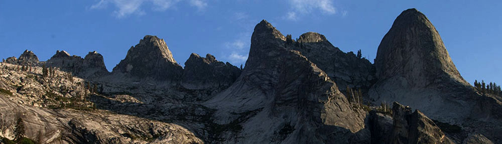
The Great Western Divide
Sequoia is also home to a parallel range of impressive peaks known as the Great Western Divide, which lies directly west of the Sierra, whose peaks rise to more than 12,000 feet. These are the mountains that prevent views of the higher eastern range from Moro Rock and the Giant Forest.
Between these ranges lie two of the deepest canyons in North America. The Kern River Valley, running to the south, is more than 5,000 feet deep for 30 miles, and to the north is the mighty Kings River, whose walls just past its northern exit from the park are arguably the deepest on the continent. The elevation of the confluence of the Kings River’s south and middle fork is 2,260 feet, while to the north looms Spanish Peak, at more than 10,000 feet.
Basin and Range
To the east of the Sierra lies the Basin and Range, a massive geographic formation that encompasses Nevada, parts of Utah, Arizona, and New Mexico and stretches southward far into Mexico. To the west are the canyons of Sequoia, the Great Western Divide and its foothills that merge into the fertile San Joaquin Valley far below.
The Basin and Range consists of long, north to south mountain ranges that are separated by long, flat valleys, or basins. Death Valley National Park is found here, merely 50 miles east of the forested heights of the Sierra. This area of the Basin and Range lies in the rain shadow of the Sierra, and thus is comprised of largely arid desert land.
This region is thought to have evolved through a process known as lithographic expansion, in which the relatively thin layers of the Earth’s crust and upper mantle are stretched east to west by tectonic plate movement along faults, leaving long thin mountains and pancake flat valleys that stretch north to south as far as the eye can see. This process leaves sunken areas, known as graben, and raised areas, known as horst.
As we’ll learn shortly, the Basin and Range region is thought to have played a role in the dramatic formation of the Sierra, although its complete influence is not entirely understood and remains the subject of heated debates that occasionally end in bar brawls and fisticuffs among pocket-protector wearing scientists today.
Grinding Granite
The Sierra Nevada Mountains are comprised mostly of granitic rock, such as granite, diorite and monzonite. These types of rocks are formed when molten rock cools beneath the Earth’s surface, often during periods of subduction, which generates extremely high temperatures due to the intense friction of tectonic plates grinding against one another under tremendous pressure.
During the Cretaceous Period, between 70 and 140 million years ago, continental shifting was well underway The ancient continent of Pangea was completely fractured by this point, and global landmasses were beginning to take the shapes that we see today. Large tectonic plates were moving due to molten activity far below the earth’s surface, growing oceans and reshaping continents.
As the great North American Continent was pushed westward, its course collided with the massive Pacific Plate, which was forced below in a process known as subduction. Such activity, and the friction it created, resulted in unfathomable temperatures which forced steam and water from deep within the Earth’s surface to burst upward, melting rock as it went. This rock eventually cooled while still buried, not to see the light of day for the next 60-90 million years.
Tilted Mountains
It is commonly agreed that the Sierra Nevada Mountains are relatively young, and that the striking mountains witnessed here today, especially from the east, are an uplifted and tilted block of the Earth’s crust.
As indicated earlier, there is great debate in the scientific community regarding the effect of the Basin and Range formation upon the structural rise of the Sierra. However, it is generally thought that somewhere around 10 million years ago, lithographic expansion (east to west stretching of the earth’s upper mantle and crust) led to the Basin and Range’s westward expansion.
As the graben edge of the Basin and Range moved westward, it undercut massive blocks of granitic rock, remnants of the molten subduction of the Pacific Plate some 100 million years earlier, forcing them skyward.
The liquifying heat produced from these movements effectively worked to erode the eastern edge of the granitic block, leaving it thinner and thus more “buoyant”, which allowed it to rise somewhat faster than the western edge, giving the rising mountains a jagged eastern edge, while the western side came to consist of more gentle slopes.
Slowly the blocks of granite moved upward, rising ever-so-slightly with each passing earthquake. This upward-bound mass of granitic rock would one day produce the mighty Sierra Nevada Mountains, home to the tallest peak in America outside Alaska and the 2nd greatest vertical prominence found in the lower 48, as Mount Whitney towers some 10,080 feet above the Owens Valley to the east.
Glaciation
Over the next few million years, at least four periods of glaciation in the northern hemisphere deposited thick layers of ice upon these growing mountains. Lower lying areas attracted large fields of ice, which guided by gravity, crept toward the valleys below, grinding rock against rock in slow, yet violent fits of erosion, carving large gigantic canyons of unparalleled grandeur.
As the ice retreated, plant life began to take hold in the montane ecosystems of the Sierra and mixed conifer forests formed, soon boasting stands of ponderosa pine, white fir, and sugar pine. Among these began to appear groves of a tree that can be traced to the Triassic Period, some 200 million years ago, before dinosaurs roamed the Earth.
Sequoiadendron Giganteum
The Sequoiadendron giganteum (giant sequoia) was once a dominant tree in North America and Europe, along with its cousin, Sequoiadendron sempervirens (coastal redwood). During the Jurassic Period, 180-135 million-years-ago, the planet was warm and moist, holding higher temperatures that were more accommodating to the large trees.
Some time near the end of the Cretaceous Period, 35-70 million-years-ago, the dinosaurs enjoyed their final days, and the Earth’s climate began to change, cooling and drying.
These conditions were not favorable to the large trees, and their species began a retreat that continues to this day. Around 20 million years ago, the Sequoiadendron became extinct in Europe, and continued a westward movement in North America.
Today, these trees occupy a dismal fraction of the landmass they held in days-gone-by, as they are now only found in a thin strip of the Western Sierra, between 5,000 and 7,500 feet.
Guide to Sequoia
Relevant Links
National Park Guides
All content found on Park Junkie is meant solely for entertainment purposes and is the copyrighted property of Park Junkie Productions. Unauthorized reproduction is prohibited without the express written consent of Park Junkie Productions.
YOU CAN DIE. Activities pursued within National Park boundaries hold inherent dangers. You are solely responsible for your safety in the outdoors. Park Junkie accepts no responsibility for actions that result in inconveniences, injury or death.
This site is not affiliated with the National Park Service, or any particular park.