Sequoia National Park is all about big things. Here, we find the biggest trees on Earth, the tallest mountain in United States outside of Alaska, and somewhat surprisingly, one of the most remote wilderness areas in the contiguous US.
Guide to Sequoia
Sequoia National Park
Observing the Sierra Nevada Mountains that make up both Sequoia and its sister park, Kings Canyon from Mount Tyndall, a member of the 1864 Brewer Expedition described the landscape as “thin ridges topped with pinnacles sharp as needles, successions of great amphitheaters with crowning precipices. Over-sweeping snow fields and frozen lakes, everywhere naked and shattered granite…”
Sequoia is a majestic park whose rugged terrain makes it seem even bigger than it is. At more than 400,000 acres, 850,000 when combined with Kings Canyon, this place is large, no doubt. Nearly 40 separate sequoia groves containing nearly 16,000 individual trees are found between the two parks. Given that elevations range from 1,300’ to more than 14,000 feet, covering distance here is a challenge, even for the most physically adept park junkies.
Exploring Sequoia
Most visitors will enter the park and motor through its forests at least partly on the General’s Highway. This highway, which was completed in 1935, winds through the park, leading from the southern entrance at Ash Mountain, exiting some 33 miles later, near Stony Creek Village. The highway then leads through Sequoia National Forest, and ten miles further, enters Kings Canyon NP.
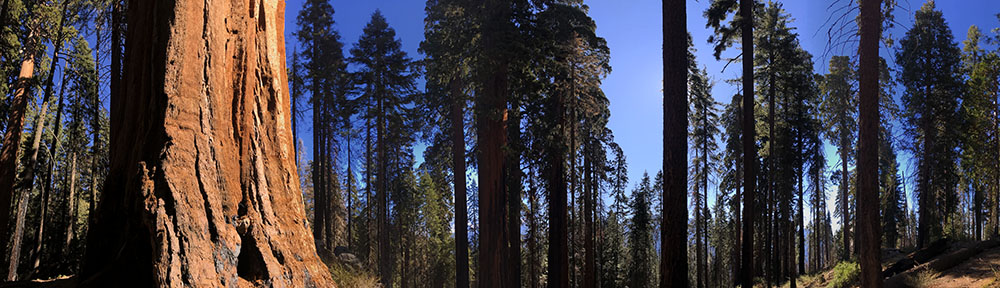
The Ash Mountain entrance is around 1700’ and its lower elevation is home to blue oak savanna and scattered chaparrals. These gnarly oaks can be hundreds of years old, and often look the part. As the road ascends, it passes through a diverse mixed conifer forest that blankets the steep landscape with patches of giant sequoias separated by stands of ponderosa pine, white fir, sugar pine and cedar.
The forests of Sequoia beg visitors to leave the pavement. The spectacular scenery cannot be fully appreciated from ye olde metal coffin, and very little of the park is accessible by vehicle.
No roads cross the Sierra Nevada from east to west and all roadways into the park are found on the western slope. In order to travel by car from east to west, or vice versa, one must travel north to Yosemite and cross via Tioga Pass, or south to Tehachapi or Walker Passes. It is a long way around.
The Giant Forest
The Giant Forest area is the centerpiece of the park and is home to the Giant Forest Museum, which curious tree lovers will not want to miss. A one-mile loop trail leads visitors past 5 of the 10 largest trees in the world in the Giant Forest. Not far away, the Congress Trail provides a slightly less crowded 2-mile loop trail that begins near the General Sherman Tree. More than forty miles of trail can be accessed from this area alone.
“Most of the Sierra trees die of disease, fungi, etc., but nothing hurts the Big Tree. Barring accident, it seems to be immortal.”
John Muir
Nearby is the Crescent Meadow Road, which provides access to Moro Rock, at 6,725 feet. For those that make the effort to scale the 400 steps that lead to its summit, a commanding view unfolds over the Middle Fork of the Kaweah River which lies far below. On clear days, a keen eye can detect the California coastal range, some 100 miles to the west, while peaks of the Great Western Divide rise to the east, preventing sight of the Sierra Nevada, which lie just beyond.
This same road leads under the Tunnel Log, a fallen sequoia that workers decided was easier to tunnel through, rather than to remove from the roadway. The road is closed to vehicular travel in winter, and is accessed only by shuttle or foot on summer weekends to avoid traffic congestion in the busy Giant Forest area.
Crystal Cave
Attractions vary and include more than just the biggest trees on earth and sick mountains with incredibly scenic trails. There is a cave to be explored as well. A twisting 9-mile side road leads to the Crystal Cave, the only cave in the park that is open to public access. There are more than 270 caves in the park, and more seem to be found each year, with Liburn Cave boasting the longest underground passage in California, at 17-miles-long.
The Crystal Cave can be explored via a ranger-led tour, mid-May through September, with a ticket that can be purchased online, or at either the Foothills or Lodgepole Visitor Centers. This cave is unique among American caves, as its intricate passages were created by water that flowed over marble, as opposed to limestone as is the case in most other North American caves.
Mineral King
Another area of interest lies at the southern end of the park. Mineral King contains some of the most scenic hiking in Sequoia and is accessed by a ridiculously twisty 25-mile road that leaves California Highway 198 from about half way between Three Rivers and the Ash Mountain entrance.
Here, trails depart from about 7,500’ and provide sweeping views of turquoise lakes in glacier-carved basins that lie far below. This area is a recent addition to the park, acquired in 1978 after a decades long attempt by the Disney Corporation to open a ski resort in the remote location.
Mount Whitney
The tallest peak in the lower 48 is located atop the jagged ridge of peaks that tower above the Owens Valley, which lies in barren solitude far below. Mount Whitney stands at 14,494′ and can be accessed from the west via a number of routes including the John Muir Trail, or more easily from what is known as the Whitney Portal, on the Sierra’s east face.
The peak is quite popular these days. Summit hikes and climbs require a permit, which can be acquired online, or in person at the Eastern Sierra Interagency Visitor Center, in Lone Pine, California.
The Whitney Portal is steep and the ascent is quick. The trip is 22 miles roundtrip, and hikers will gain over 6,100′ of elevation, and of course, retrace their steps back down. Some choose to camp and make the trek a two or three day affair, but some prefer to just blast it out and get back to town for a phat cheeseburger and couple of well-earned beers.
Playtime
Mountain climbing is as wide open as it gets here and peakbaggers will have their hands full with access to a lifetime of possible routes up steep, isolated granite peaks. Rock climbers can find plenty to keep their hands raw as well, but most routes will be a bit removed from the main areas of the park, aside from the Moro Rock area, which has several routes below its summit. Check park regulations regarding peregrine falcon nesting closures.
Winter activities are abundant as well, snowshoeing and cross-country skiing is a wonderful way to escape the humdrum of everyday Sequoia. Try the six-mile trail from Wolverton Meadow to the Pear Lake Ski Hut for an overnight stay. Reservations are required and the stay is under $50 per night as of 2019. See the activities page here at park junkie for contact info.
The park offers ranger-led snowshoeing tours on Saturdays and holidays, weather permitting. The trip lasts two hours and usually begin at the Giant Forest Museum. Snowshoes are loaned for free, but group size is limited. Stop by the visitor centers to inquire, or contact the Sequoia Parks Conservancy. See the activities page here at park junkie for contact info.
Equestrian pursuits are cool here too. Visitors can experience the park the way the Army soldiers that first patrolled the area did, on horseback. Bring your favorite steed and strike out on your own, or join a guided tour of 1-2 hours, or just go for it and sign up for a multi-day pack trip into the wild.
Of course, the main recreational activity here is simple hiking and backpacking. There are trails winding all through these mountains and when combined with Kings, hikers have more than 850 miles of rugged pathways upon which to trod. In this wilderness, hikers can find themselves further from any roadway than anywhere else in the lower 48.
Backpacking requires an overnight permit, and the park’s backcountry is popular, so a quota system is in place during summers. Bears wander these hills, so bear-cans are required. Check out the activities page for more details on backpacking in Sequoia and Kings Canyon.
Mountain scenery does not get much better than what can be found along the High Sierra Trail, which winds easterly through the heights of the Sierra and down into the Kern River Valley.
Park Junkie Verdict
Some of the most memorable scenes of my life were captured in Sequoia. My trips in the Whitney Portal region were mind blowing, as were my arrivals at remote camps, such as the Hamilton Lakes.
My first view of these lakes was one of the most serene sights my eyes had ever enjoyed, and I’ll never forget that view after a long day’s march. It was the most unblemished natural setting I had ever witnessed and the sight left me spellbound at my camp for hours… I just sat and stared…
Go check it out… I bet you’ll sit and stare as well.
See ya there…
Guide to Sequoia
Relevant Links
National Park Guides
All content found on Park Junkie is meant solely for entertainment purposes and is the copyrighted property of Park Junkie Productions. Unauthorized reproduction is prohibited without the express written consent of Park Junkie Productions.
YOU CAN DIE. Activities pursued within National Park boundaries hold inherent dangers. You are solely responsible for your safety in the outdoors. Park Junkie accepts no responsibility for actions that result in inconveniences, injury or death.
This site is not affiliated with the National Park Service, or any particular park.