Zion is a hiker’s dream. There are plenty of trails in this desert wonderland that lead to incredible vistas and to stunning overlooks. Some of these routes will challenge even the most adept adventurers. Hiking in Zion will satisfy your thirst for the great outdoors.
Be advised, you alone are responsible for your safety. Each year, Zion loses hikers to the effects of gravity. This is a vertical park, and falls are usually deadly. Know your limits, hike with a prudent friend, take water and be prepared. Your safety is on you…
Guide to Zion
Hiking in Zion
Here are some of Park Junkie’s favorite hikes in Zion listed by one of 4 regions of the park. Distances are roundtrip unless otherwise noted. Hikes in Zion Canyon will be extremely busy, with literally thousands of visitors each day, especially during the summer months.
Zion Canyon
Pa’rus
3.5 miles / 50-feet elevation change / easy
Easy paved trail that leads along Virgin River from visitor center to Canyon Junction. Bike and pet-friendly trail. Hike begins at Zion Canyon Visitor Center.
Weeping Rock
0.5 miles / 100-feet elevation change / easy
Easy, short but steep hike with minor drop-offs. Paved trail that leads to a hanging garden fed by dripping spring water that “weeps” from the sandstone rock of Zion Canyon. Hike begins at Weeping Rock, shuttle stop #7.
Riverside Walk
2 miles / 60-feet elevation change / easy
Easy hike on paved trail into the Zion Narrows with minor drop-offs. Trail leads along the Virgin River, with spring-fed weeps creating hanging gardens on canyon walls. Another Zion classic for those with little time, and provides a great introduction to the Zion Narrows. Trail begins at Temple of Sinawava, shuttle stop #9.
Emerald Pools
1.2-3.5 miles (depending on loop) / 400-feet elevation change / easy to moderate
Easy hike, however, potential fatal falls are possible and have occurred. Numerous railings installed to prevent erosion and off-trail travel. Trail leads to three beautiful desert oasis pools which lie along a small spring-fed creek that meanders through wooded terrain. Gorgeous views of Zion Canyon and small waterfalls. Good, short, family-friendly hike. A classic Zion hike for those with little time. Trail begins at the Zion Canyon Lodge, shuttle stop #5 or the Grotto, shuttle stop #6.
Watchman
2 miles / 375-feet elevation change / easy to moderate
Hike to excellent view into Zion Canyon and the town of Springdale. Minor drop-offs with cliff tops at trail’s summit. Little to no shade. Trail begins at Zion Canyon Visitor Center.
Hidden Canyon
2 miles / 370 feet elevation change / moderate to strenuous
Hike begins on Observation Point Trail, but splits off after a short climb, and leads into a deep canyon with cooler temperatures. Trail has major drop-offs and exposure. Chains have been installed in exposed areas. Perhaps the best choice for those with fear of heights. This trail provides access to a large slot canyon and hikers can explore quite a ways into the canyon before increasingly difficult obstacles lead most to turn around. Trail begins at Weeping Rock, shuttle stop #7.
Observation Point
8 miles / 2300 feet elevation gain / strenuous
Excellent hike that leads through Echo Canyon to top of Zion Canyon. Far-reaching views down into Zion Canyon and down onto the summit of Angel’s Landing. Major drop-offs. Trail provides access to Zion’s upper east side, including the East Rim Trail, which leads to the Cable Mountain and Deer Trap Mountain trails. Trail begins at Weeping Rock, shuttle stop #7.
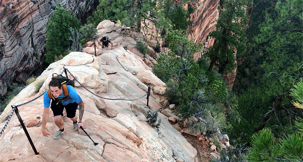
Angel’s Landing
5 miles / 1500-feet elevation change / strenuous
Hiking in Zion is EPIC… And perhaps no hike is more epic than Angel’s Landing. The hike leads up, up and up along narrow, exposed ridge to summit of massive sandstone monolith that towers above Zion Canyon. Trail is mostly paved for first 2 miles to Scout’s Lookout. From here, the trail features chains to aid in protection from falls. Major drop-offs and exposure. Perhaps not a wise choice for those with fear of heights. Excellent views all around. An incredible hike, a Zion classic. However, be prepared to share the trail with most of Manhattan. Hike begins at the Grotto, shuttle stop #6.
As of 2022, hikers who wish to ascend the peak through the “chain section”, will need to obtain a permit. These permits can be reserved through the park’s fabulous corporate friends at Rec.gov through the link below.
NPS – Zion – Angel’s Landing Permit
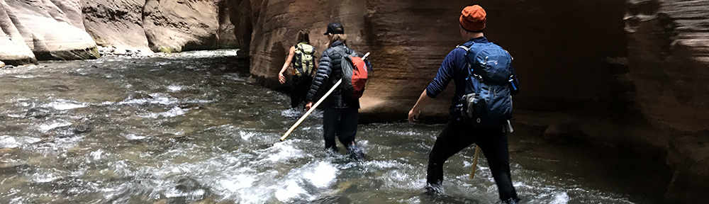
The Narrows
10 miles / river walk / up & back
An epic adventure that leads hikers into the depths of Zion Canyon. Hike can be done top-down, (listed on east side hikes) but more commonly is accessed from the Temple of Sinawava. Route ascends the Virgin River in a canyon walled with vertical red cliffs that tower more than 1,000 feet above.
Hikers walk in the river, over rocks that can seem like greased bowling balls. Many falls occur and some areas may require swimming. Up-canyon hikes are limited to the Wall Street area and a turn around here will provide a 10 mile trip, but earlier turn arounds allow shorter trips of any distance. Trail begins at the Temple of Sinawava, shuttle stop #9.
East Side
Canyon Overlook
1 mile / 170 feet elevation change / easy to moderate
Trail leads along the rim of Pine Creek Canyon, with major drop-offs into the canyon. Route is mostly fenced for safety. Fun, rocky hike that leads to fantastic view of Zion Canyon and the Pine Creek drainage below. Trail begins at the east end of the Mount Carmel Tunnel. Parking is limited during peak hours in this congested area.
East Rim Trail
11 miles (one way) / 1500 feet elevation gain / strenuous
Trail leads from park’s east entrance along Zion’s east rim, before dropping into Zion Canyon, where it connects to the Weeping Rock area. Upper section of this trail sees relatively little traffic and will insure stretches of solitude. Must arrange car shuttle from Canyon Junction to east entrance. Hike begins at either Weeping Rock, shuttle stop #7 or East entrance of park on Hwy 9.
The Narrows (top-down)
16 miles / 1500 feet elevation change / strenuous / permit req’d
This hike requires a permit. Can be done as a long day trip, or overnighter. This is truly a Zion must do for those of able body. Hike leads from Chamberlain’s Ranch in the upper realms of Zion’s east side into the heart of the park. The top-down option provides a true picture of Zion’s origins.
Hike begins in wooded area and descends through 15 miles of sandstone cliffs carved by the Virgin River. Travel can be complicated in areas, with swimming necessary in some places depending on water levels. Trail begins at Chamberlain’s Ranch and exits at the Temple of Sinawava, shuttle stop #9. Must arrange shuttle to Chamberlain’s Ranch. Shuttle services available in Springdale for a fee.
Kolob Terrace Road
Northgate Peaks
4.4 miles / 150-feet elevation change / easy
Higher elevation trail that meanders through ponderosa pines leading to a 7,200 foot peak that provides excellent views of the park’s rugged western terrain. Trail begins on Kolob Terrace Road at the Wildcat Canyon Trailhead.
Right Fork
11.8 miles / 700 feet elevation change / moderate – scrambling
Trail runs along creek through a land of vertical buttes and red canyon walls to an upper area that holds numerous year-round waterfalls. Route is relatively easy in beginning, but eventually scrambling over fallen rocks will be necessary to attain access to Double and Barrier Falls. This is a primitive route with little traffic. A nice getaway after the crowds in Zion Canyon.
Left Fork – Subway (bottom up)
7 miles / 600 feet elevation change / strenuous- scrambling / permit req’d
All hikes in the Left Fork require a permit. This adventurous route leads from the Left Fork Trailhead into a red-walled canyon and continues upstream for 3 miles. At this point, hikers enter an unbelievable tunnel-like section of canyon with clear green pools of water that are out of this world. Rocks here are slippery and footing is tricky. Upstream travel past the Subway pools is prohibited and obstacles usually prevent upstream travel. Once you’ve enjoyed this area, turn around and retrace the route to the Left Fork Trailhead. Trail begins at the Left Fork Trailhead on the Kolob Terrace Road.
West Rim
14.2 miles / 3400 feet elevation change / strenuous
This route leads from the top of the park to the bottom, or vice versa. Beginning at 7,900 feet at Lava Point, this trail leads across the remote western rim of Zion. The trail travels through forests of ponderosa pine and provides absolutely spectacular views over the park’s western landscape.
After several ups and downs, and an unforgettable section skirting the cliffs above Phantom Valley, the trail begins its drop into Zion Canyon. Soon hikers arrive at Scout’s Lookout and the fabled Angel’s Landing trail. From here, a descent into the maddening crowds below brings hikers to long for the solitude enjoyed on the trail far above. Trail begins at Lava Point and ends at the Grottoo, shuttle stop #6. Shuttles can be arranged in Springdale.
Kolob Canyons
Timber Creek
1 mile / 150 feet / easy
Short trail leads to overlook of the Kolob Finger Canyons.
Taylor Creek
5 miles / 500 feet elevation change / moderate
The Taylor Creek Trail is one of the few trails in this somewhat quiet area of the park, yet it is a fabulous getaway from the crowds of Zion Canyon. The trail leads along its namesake creek and leads past a couple of historic cabins that were built in the 1930s, prior to this area’s addition to the national park in 1956.
Winding its way through a forest of piñon and juniper pines, the trail soon leads to the Double Arch Alcove. This cave-like spring-fed formation provides an exciting memorable apex on an otherwise peaceful trail. Trail begins at the Taylor Creek Trailhead on the Kolob Canyons Road, just off of exit 40 on Interstate 15.
Kolob Arch (via La Verkin Creek)
14 miles / ≈ 1000 feet elevation change / strenuous
The La Verkin Creek Trail provides access to a remote corner of Zion, leading along glowing red cliffs into a canyon whose walls slowly grow tighter with eastward travel. There are a number of reasons one may venture into this area. The most likely is a desire to see the Kolob Arch, which at 287 feet in length, is one of the longest free standing arches in the world.
Hikers depart Lee Pass and descend into La Verkin Creek before hiking about 6.2 miles upstream before reaching the side trail to Kolob Arch. The La Verkin Creek Trail continues upstream from here, providing access to the rarely visited jewel of Beartrap Falls, and the Hop Valley Trail, which leads toward the Kolob Terrace Road. The Kolob Arch Trail climbs the north side of the drainage, leading to a view of the massive arch. From here, hikers retrace their steps to Lee Pass, with the 1,000 foot climb back to their waiting automobile. Trail begins at the Lee Pass Trailhead.
Guide to Zion
Relevant Links
Explore Your National Parks
All content found on Park Junkie is meant solely for entertainment purposes and is the copyrighted property of Park Junkie Productions. Unauthorized reproduction is prohibited without the express written consent of Park Junkie Productions.
National Parks and the outdoor recreational activities pursued within their boundaries hold inherent dangers. YOU CAN DIE. I regret to inform you, but you’re going to die anyway… Nevertheless, you are solely responsible for your safety in the outdoors. Park Junkie accepts no responsibility for poor choices made in the wilderness or beyond the controlled area.
Obviously, this site is not affiliated with the National Park Service, or any particular park or park institution. Enjoy your day…