Despite the seemingly endless rugged terrain that exists in this desert park, Zion is relatively small compared to many other classic western parks. There are a limited number of trails here and only a few true on-trail backpacking routes.
Nevertheless, backpacking in Zion is a most rewarding pursuit. Those that hoist a pack onto their shoulders and head out into the wild will undoubtedly find scenes that will become screensavers in their minds.
Guide to Zion
Zion Backcountry Permits
These are the most popular backpacking routes in Zion. All overnight backcountry trips require a permit. Online reservations are available for some sites, but some are held for walk-ins. Backcountry users must visit the backcountry desk to pick up the physical permit. Reserve your campsite and permit here:
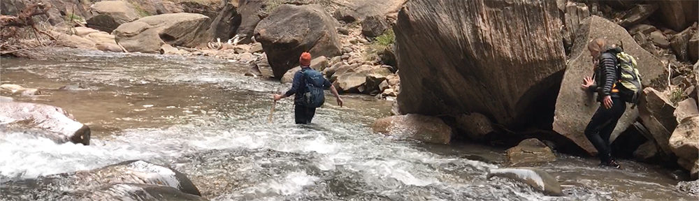
The Narrows
16 miles (top down) / 1500 feet elevation change / strenuous
The top-down Narrows route is one of the coolest backcountry hikes you may ever do and is one of the more unique options for backpacking in Zion. A journey through the Zion Narrows leads eager adventurers through one of the largest sandstone slot canyons on Earth and the scenery is simply spectacular.
read moreThe Hike
On this one, you’ll be hiking in the flowing water of the Virgin River whose underwater rocks may seem more like greased bowling balls to hikers with heavy overnight packs on their back.
This hike begins on the upper plateaus east of Zion, at Chamberlain’s Ranch, which sits on private property.
This is a remote area and hikers must arrange a private vehicle shuttle or purchase a shuttle from an outfitter that offers such services in the town of Springdale, at the park’s southern entrance.
The hike exits the Narrows at the Temple of Sinawava in Zion Canyon, where hikers board the Zion Canyon Shuttle to return to civilization.
The route leads across a couple of miles of private property and past the remains of Bulloch’s Cabin. Soon hikers enter the creek and hike in the water for a short while before entering Zion National Park.
Slowly, the adventure bound are led lower into the depths of Zion as the walls become taller and the water flow increases. At the confluence of Deep Creek, the water flow becomes noticeably greater, as the amount of water flowing is more than doubled at this point.
Hiking south from here leads past the numbered campsites and toward the gorgeous hanging gardens of Big Springs, which essentially marks the entrance to Wall Street.
This is the tallest and narrowest part of the Narrows, where the light of day is darkened by the sheer depth of the canyon. This area offers no immediate high ground, and thus is the most dangerous in the event of a flash flood, so keep weather conditions in mind in this area.
Soon, “top-down” Narrows hikers will begin to encounter the “day hikers” advancing from the bottom of the canyon. At this point, the beauty of the Narrows does not lessen, but soon may seem blemished by the sheer amount of people that are encountered. Literally thousands of people venture into this area each day during summer months.
There are nevertheless some spectacular sights on the way out. One possible side trip is a trek into Orderville Canyon, (which can be descended top-down with a permit).
Near the end of the hike, a gorgeous waterfall enters the Narrows from the east side of the canyon. This is Mystery Falls, the terminus of the Mystery Canyon canyoneering route (which can be descended top-down with permit).
From here, the hike out to the shuttle is quick, simple and direct, just go for it. Congratulations on a fine journey…
Campsites in the Narrows
There are 12 campsites along this route. Some sites require a longer hike the first day, such as High Camp (campsite #12), while others, such as Deep Creek (campsite #1) make day 1 a breeze and leave the struggle for day 2. All sites offer flat dry refuge from the flowing water.
More Info
West Rim
16.2 miles / 3600 feet elevation change / strenuous
The West Rim trail is a Zion classic and a perfect introduction to backpacking in Zion. This route offers stunning views over the park’s jagged western landscape of sandstone peaks and deep, dark canyons.
read moreThe Hike
The trail can be hiked from Lava Point to the Grotto as a “top-down” route, or vice versa for those who want a real workout.
Of course hikers could also depart from the Grotto, hike up to the rim, camp and retrace their steps back down to the canyon floor.
This is the most simple logistically, as it does not require a vehicle shuttle. For those that choose the one-way method, a shuttle to Lava Point will be necessary. Numerous outfitters in the town of Springdale offer shuttle services to Lava Point for a nominal fee.
Campsites on the West Rim
There are 9 campsites along the trail that offer an opportunity to spend the night in the heights of Zion. Park Junkie highly recommends this route. Any wise therapist would likely do the same.
More Info
East Rim
10.5 miles / 2300 feet elevation change / moderate to strenuous
The East Rim Trail is not a popular backpacking destination in Zion and few visitors make the effort to see this area. This quiet trail offers little in the way of the abrupt scenery that is common along the West Rim Trail. Rather this sandy trail slowly winds through small white cliffs and stands of ponderosa pines as it runs across the East Mesa.
read moreThe Hike
Those who wish to explore the upper east side of the park may wish to use this area as a base camp to hike to Cable and Deertrap Mountain. It is also often a necessary stop for those seeking to complete the Trans-Zion Trek.
This is a one-way trail that begins at either the East Entrance to Zion on Hwy 9, or at the Weeping Rock shuttle stop #7 for those who need a more strenuous alternative.
The East Rim offers the option for a side jaunt to the overlooks of Cable Mountain, which adds about 5 miles from Stave Spring, and Deertrap Mountain, which adds about 7 miles. Both of these viewpoints come highly recommended here at park junkie, and you’ll likely nary see a soul at either destination.
Stave Spring is an active spring, but be aware that flow here will likely be very low in summer months, so inquire with the park backcountry desk about water when acquiring your permit.
Campsites on the East Rim
There are no designated campsites along this route, although camping is allowed in the upper regions to the east of Echo Canyon. There are not a lot of idealistic campsites along this trail, but the best area to pitch a tent is probably in a stand of pines near Stave Spring.
More Info
La Verkin Creek
14-23 miles (route dependent) / 1000 foot elevation change / strenuous
The La Verkin Creek Trail presents an opportunity to evade the Zion Canyon crowds. This hike departs from Lee Pass, in the Kolob Canyons section of the park, and leads into the remote La Verkin Creek valley. The trail parallels a beautiful bubbling desert brook and winds into the depths of an ever-tightening canyon, which eventually ends abruptly at the surprising Beartrap Falls.
read moreThe Hike
This trail’s most common use is as a route to the Kolob Arch, which at 287 feet in length is one of the longest arches in the world. The arch hike can be completed as a 14 mile route. Many accomplish this hike as a day trip, but the abundance of beautiful campsites along the creek makes this one of my favorite areas in which to camp in Zion.
An overnight stay in this area provides the time needed to venture further upstream, into Beartrap Canyon. Several great little campsites are located under tall pines in this canyon, past the turnoffs to Kolob Arch and the Hop Valley Trail, which runs south and connects to the Kolob Terrace Road. This is a great option and offers some of the most remote terrain for backpacking in Zion.
Campsites on La Verkin Creek
There are a number of excellent campsites along La Verkin Creek, and this is one of Park Junkie’s favorite camping areas in Zion. There are 10 sites between Lee Pass and Kolob Arch, and 3 more further upstream, beyond the junction with the Hop Valley Trail.
More Info
Chinle Trail
15.5 miles / 700 feet elevation change / mostly moderate
This is a rarely traveled route in the low desert ranges on the south side of Zion, which can be brutally hot in the summer. Views are stellar, and it’s a quiet trail compared to the main canyon. This makes it a good option for backpacking in Zion.
read more
The Hike
The Chinle Trail is probably better enjoyed as a winter trip, when snow and ice forbid adventure in the park’s higher areas. The views up toward Mount Kinesave and Cougar Mountain are stellar, but there are few overlooks, but none of the iconic Zion canyon views are found here.
The hike departs from the entrance to a small community just outside Springdale, known as Anasazi Plateau. This congregation of desert homes did not exist when the trailhead was placed here, only springing up since the early 2000s.
Turn into Anasazi Way and drive a couple of hundred feet before turning into a parking lot on the right. The first mile of the trail will be along a blacktop road which passes several houses. A sign soon directs hikers to the north along a dirt trail and departs civilization at the Zion National Park entrance gate.
The trail is sandy with areas of clay which become a nightmare if wet. Travel is mostly level, with slight increases and decreases in elevation. The trail was previously known as the “Petrified Forest Trail” due to the amount of this material deposited in the area. Do not take the rocks. They are meant to stay where they are. Don’t be a loser…
For those that would like to make a loop hike out of this journey, the possibility exists to use Coalpits Wash as an exit, or entrance. Keep in mind this will require a shuttle or hitchhike back to the Chinle Trailhead.
Campsites on the Chinle
The Chinle Trail connects to Huber Wash, Scoggins Wash and eventually to Coalpits Wash. There are 5 campsites near where the Scoggins and Coalpits wash areas intersect the Chinle Trail, and a 6th site to the south along Coalpits Wash.
More Info
Trans-Zion
47.8 miles / ≈ 10,000+ feet / strenuous
This is the route to do if your really wanna tell your friends you got your fill of backpacking in Zion. The Trans-Zion hike runs from the Kolob Canyons region to the East Gate of the park. Hikers can choose to move north to south, or vice versa. Most folks take 3-5 days to hike this route, although the ultra-light and trail-running community is constantly advancing times. Some have reported doing the route in under 8 hours… have fun!
read moreThe Hike
The Trans-Zion connects all of the main corridor trails that run from northwest to southeast. The La Verkin Creek, Hop Valley, Connector Trail, Wildcat Canyon Trail, West Rim and East Rim Trails are combined to allow such a traverse. The scenery witnessed on this route offers some of the best that Zion has to offer. In my opinion, if you’re doing this trail but once, you’ll wanna be able to take it all in slowly, so give yourself some extra time to sit on that rock and contemplate your existence. There are numerous side trails that you may wish to explore as well, and this is not possible on a mad dash though the park.
This is a hike that you’ll want to do according to the seasons. Spring and Fall are likely your best bet, as the summer is brutally hot and many areas offer nothing but sun. Winter often deposits a few feet of snow in Zion’s high country and you’ll spend quite a bit of time in that zone, so it may not even be possible during some winters.
So if you’re feeling like a badass, go get some on the Trans-Zion trek. It’s likely you won’t regret it… Enjoy…
Campsites on Trans-Zion
Hikers on the Trans Zion must obtain overnight camping permits and can reserve sites along the trail in advance.
More Info
Guide to Zion
Relevant Links
Explore Your National Parks
All content found on Park Junkie is meant solely for entertainment purposes and is the copyrighted property of Park Junkie Productions. Unauthorized reproduction is prohibited without the express written consent of Park Junkie Productions.
National Parks and the outdoor recreational activities pursued within their boundaries hold inherent dangers. YOU CAN DIE. I regret to inform you, but you’re going to die anyway… Nevertheless, you are solely responsible for your safety in the outdoors. Park Junkie accepts no responsibility for poor choices made in the wilderness or beyond the controlled area.
Obviously, this site is not affiliated with the National Park Service, or any particular park or park institution. Enjoy your day…