Yosemite is the birthplace of the modern conservation movement. Simply put, it was the Yosemite Valley and a single grove of sequoia trees that first initiated the idea of protecting land, not for development or for financial gain, but simply for the benefit and enjoyment of the people…
Guide to Yosemite
Yosemite National Park
Yosemite is vast. Here, amid a collection of iconic scenic vistas, stand silent granite walls that rise more than 3,500 feet from a valley floor, some of the world’s tallest waterfalls, and a few of the biggest trees on our planet.
Combine these features with a wilderness of more than 750,000 acres containing nearly 800 miles of trails that wind endlessly through beautiful flowered meadows, along rushing mountain streams, beside glistening alpine lakes and over towering granite domes, and it is easy to understand how this area first inspired the park idea.
There are 3 visitor centers that provide information in the park, as well as 5 wilderness permit stations where outward bound backpackers can obtain free backcountry permits. Reservations will definitely give you an advantage when it comes to the more popular destinations.
The park has 14 campgrounds and 7 lodges, plus 5 hike-in High Sierra Camps. Reservations are recommended in most cases. It must be noted that a number of the lodges have undergone name changes due to some legal bullshit that we won’t waste our time with here. (Note that park junkie will use the original names and the replacement names will be in parenthesis.)
Exploring Yosemite
Yosemite’s physical layout can perhaps be best detailed for the would-be visitor by dividing it into 5 distinct sections: Yosemite Valley, Glacier Point Drive, Wawona, Hetch Hetchy and the Tuolumne Meadows area, which here for the sake of brevity, includes the entire Tioga Road.
Yosemite Valley
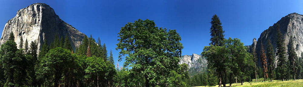
There is little, if any, room for argument, Yosemite Valley is simply awe-inspiring. Standing alone in a meadow on the valley floor and gazing upward in any direction provides a memorable, once-in-a-lifetime view for many travelers. From this vantage point, the valley encompasses all and perhaps just for a moment, it may seem that nothing else exists… This is the center of it all…
Indeed, Yosemite Valley is the center of it all… and you’ll know it the moment you begin your search for a parking space, or attempt to negotiate the throng of cars lining the four-lane-highway that today enters John Muir’s sacred temple.
Although the valley represents a mere 1% of the park’s total landmass in its 8 mile length, it receives more than 90% of the park’s visitors. Many summer days see in excess of 20,000 visitors in the valley alone. Indeed, many come only to see the valley. Most never venture further than the pullouts along the 12-mile loop that provides access into its heart.
These figures should not deter one from journeying into this wonderland and seeking adventure from its base. Quite the opposite, this area can still be enjoyed by anyone with a little patience and planning. For those willing to put in some miles on foot, crowds thin quickly on most uphill trails, and an entire wonderland lies just above the valley floor.
First of all, guests can take advantage of the free shuttle service. These buses decrease congestion and reduce pollution, not to mention relieve tension brought on by the search for that elusive parking space.
The free Valley Shuttle provides year-round access to all of the hot-spots. This route loops around the eastern Yosemite Valley and stops at or near all overnight accommodation options, stores and popular attractions. This shuttle unfortunately does not eliminate the need to drive into the valley, but does allow visitors to leave their car behind and be shuttled about once in the valley. The shuttle operates year-round from 0700 (7am) till 2200 (10pm). See the visiting page for more information.
A more independent method of transportation in the valley exists as well. Many choose to navigate the area’s attractions on bicycle once the car is parked for the day. The 13-mile Valley Loop Trail is a hike and bike-friendly trail that snakes through the upper part of the valley and offers access to the various wonders present along its route. Bike rentals are available in the village, but those who bring their own bike are able to park further downstream from the madness of Yosemite Village.
There is also an open-air tram tour of the valley available for a fee. This is a two-hour narrated ride, covering 26 miles which departs several times daily from the Yosemite Lodge.
Yosemite Valley is replete with postcard scenery, and this fact is evident the moment one enters its realm. Upon arrival, eyes are drawn upward to admire 620-foot-high Bridalveil Fall and many choose to ascend the .25-mile trail to its base, where swirling canyon winds often bless visitors with a healthy dose of spray from the waterfall.
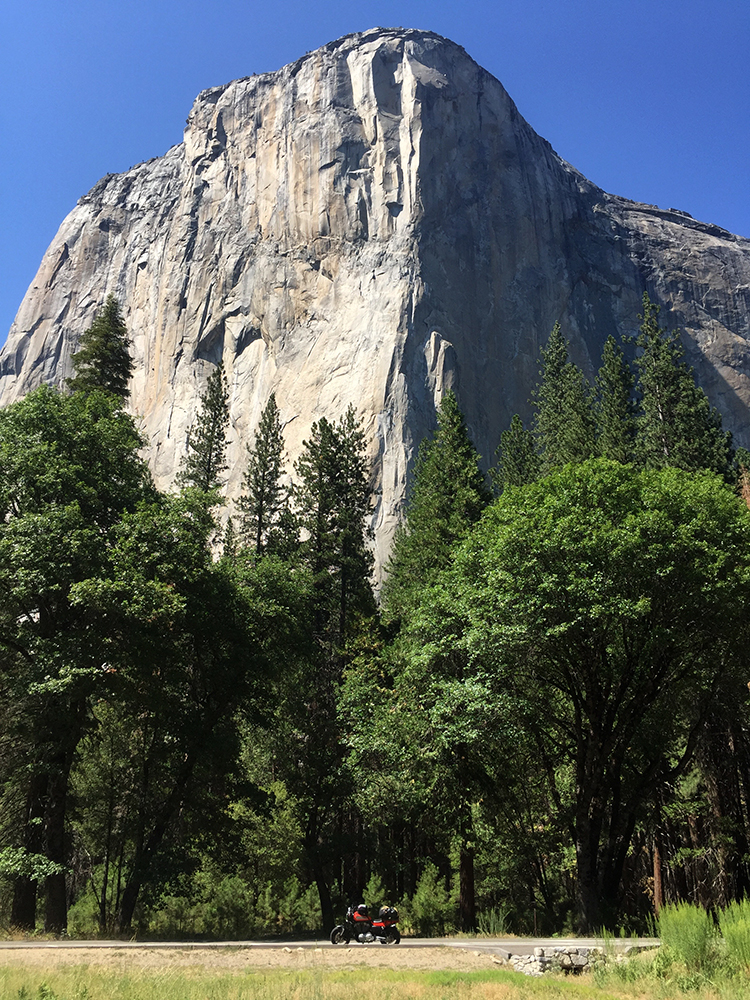
As heads turn to face the opposite side of the valley, El Capitan, the largest granite monolith in the world commands attention, rising more than 3,500 feet above the flowing waters of the Merced River, which cuts through the valley. The best roadside view of this feature will be found on the northern westbound exit from the valley, but it can be viewed from numerous pullouts along the entrance as well.
El Capitan is a legendary mecca for those in the rock climbing community. Considered a proud ascent in multi-day fashion just a decade ago, today’s climbers regularly set speed records on its face that make mother’s shudder in terror.
In June of 2018, Alex Honnold and Tommy Caldwell set an astonishing new record of just 1 hour 58 minutes and 7 seconds on the 3,000 foot Nose, after breaking their own record three times within a week. This mark will likely not stand for long, as Honnold seems to be right at home cruising up such terrain without hindrance of that pesky fear that plagues many who strain to attain simple roped ascents of such magnitude.
As spell-bound visitors move further up the valley, the Cathedral Rocks appear to the south and to the north the 1,000 foot Horse Tail Fall comes into view, which is a photographer’s fave in mid to late February, when crosslight at sunset renders the fall glowing red, as if it were on fire.
Soon, the famous Yosemite Falls appears to the north, comprised of the Upper, middle cascades and Lower falls that when combined at 2,425 feet (739m), form the tallest waterfall in North America and the fifth tallest in the world.
This waterfall is fed largely by snowmelt, its flow dependent on an adequate winter snowfall and is often dry by mid-summer in years of drought.
An eight-mile hike gaining 2,700 feet (823m) places physically fit hikers at a nice natural pool, atop the falls. The Yosemite Falls Trail is one of the oldest historic trails in the park, completed in 1877.
Yosemite Village is the epicenter of this natural kingdom. Guests can find information and exhibits at the Yosemite Valley Visitor Center, as well as obtain free backcountry permits from the Wilderness Center, one of five in the park. Of course, Park Junkies will want to stop and enjoy the park movie, “Spirit of Yosemite” while here at the VC.
The village has lodging, camping and dining options, as well as a medical clinic, gift shops, the Yosemite Museum and the Indian Cultural Exhibit, which interprets the cultural history of the Miwok and Paiute peoples who once ruled this area. Nearby is the Ansel Adams Gallery, which offers prints of the famous landscape photographer’s more popular images. The village has basically everything you could want in such a setting.
For lodging in the village, it is hard to beat the famous Ahwahnee Hotel (Yosemite Hotel). Built in 1927, this is widely considered the pinnacle of National Park lodging with 123 rooms and its Majestic Restaurant. The building and its rooms are simply spectacular and at a mere $400 per night, you’ll likely be tempted to just settle in for the summer season…
See the visiting page here at park junkie for camping, lodging and other information.
A number of great hiking trails depart this area, including the park’s most popular, the Mist Trail, which cools summer hikers with fine mist from the cascading Merced River, along which the trail winds. This is the trail to Vernal Fall and Nevada Fall, as well as the main access route to the famed Half Dome, which requires a permit as passage to its summit is limited to 400 persons per day.
To the north of the village, trails lead up Tenaya Creek, stopping by Mirror Lake, which sits in the valley below Half Dome. Although the lake today appears to be more of a grassy marsh, in spring, when waters are high, there are still some good photographs to be had here, as the waters can provide a nice reflection of Half Dome, which looms overhead to the east.
Yosemite Village can be the jumping off point for some great backcountry hikes as well, although some prefer to access the higher country from the Tioga Road, as all backcountry hikes from the valley will require substantial ascent. That said, loop hikes that originate from here can be an excellent way to blaze out into the Yosemite backcountry. See the activities page for more info.
Horseback rides are offered in the valley, and rafting the Merced River is an option as well as the river flow is usually adequate for recreation May thru July. Rafts are available for rent at Curry Village (Half Dome Lodge). Visitors may also bring their own watercraft, please preserve the river bank by entering and exiting on sandy beaches.
Regardless of the planned route upon departing the valley, visitors may wish to take the Wawona Road (Ca Highway 41) south for a short distance and stop at the Wawona Tunnel, often simply referred to as “Tunnel View”.
This vantage point provides a panoramic scene that properly completes a day in Yosemite, as El Capitan, Taft Point, Half Dome and Clouds Rest tower above the forested valley below while features such as Bridalveil Fall provide accent at what is one of the most photographed vistas on Earth.
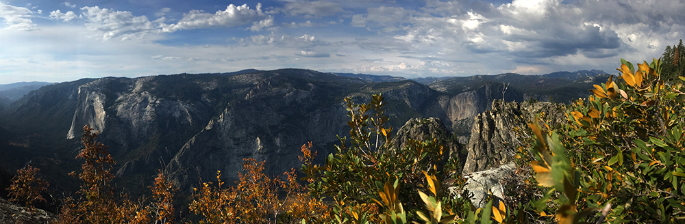
Glacier Point
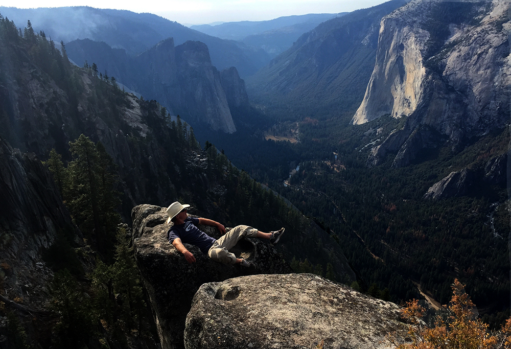
No visit to Yosemite should be considered complete without at least an afternoon drive out the Glacier Point Road. Even better, a hike up to the point from the valley floor on either the Panorama or the Four Mile Trail. The view from here is famous, and if you’re any sort of park junkie, you’ve probably seen this iconic photograph of John Muir with President Theodore Roosevelt taken on Overhanging Rock at Glacier Point in 1903.
“It is by far the grandest of all the special temples of Nature I was ever permitted to enter.”
John Muir
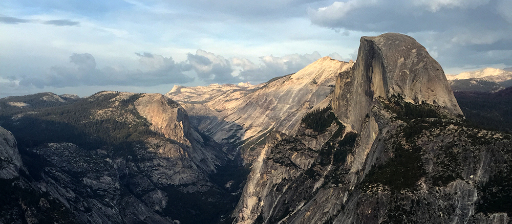
This point towers 3,254 feet above the valley floor and provides stellar panoramic views of the valley and its namesake waterfall, Half Dome and Clouds Rest, along with the upper Merced River Valley and all of the granite domes and spires that rise out of the Yosemite high country as it merges into the Sierra Nevada.
The road leading to this point is littered with options for the outdoor bound.
Near the junction with California Highway 41, is the Yosemite Ski and Snowboard Area, previously called the Badger Pass Ski Area. Although small, this is a full-service ski resort that operates mid-December through March 31, conditions permitting. There are four lifts that service a number of hills and the facility offers equipment rental, guided services and tubing.

Public Domain Image*
The Glacier Point Road is closed beyond the ski resort in winter. Further winter access on this road requires snowshoes, cross-country skis, or other self-propelled means.
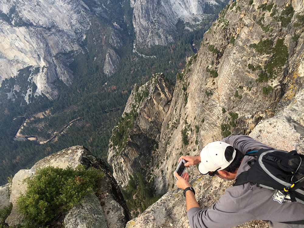
Many trails and viewpoints are found along the road, such as those leading to the Sentinel Dome and Taft Point. Both of these destinations present incredible vistas from which to enjoy the scenic wonderland below. To make a loop of these, use the Pohono Trail which winds along the southern rim of the valley past the Fissures out to Glacier Point.
Another option departs from the south side of the road, as a 12-mile roundtrip trail leads to the remote ski hut at Ostrander Lake. If done in the summer, these waters offer an incredibly refreshing break after miles on the trail, while in winter, this area becomes home to some sick backcountry skiing and snowboarding for the adequately prepared winter recreationalist.
The Bridalveil Creek campground sits right along the road and is a nice location from which to base your adventures in this area of the park. Numerous trails depart from this area provide access to the southern backcountry of Yosemite. This campground closed in winter, and is first-come, first-served.
Wawona
Located near the park’s southern entrance is the small village of Wawona, which was the early home of Galen Clark, the original voice leading the cry for the preservation of Yosemite Valley and the Mariposa Grove of giant Sequoia trees.
Here today is the Pioneer Yosemite History Center, a collection of historic structures left over from the early days, including the studio of artist Thomas Hill, who in 1903, presented Theodore Roosevelt with a painting of Bridalveil Fall that today hangs in the White House. This structure now acts as a park information center and enjoys a place on the National Register of Historic Places.
Those in need of a good night’s rest while in the area should look into the Wawona Hotel (Big Trees Lodge). This historic Victorian-style hotel was built in 1876 and offers 104 beautifully designed rooms, complete with a nine hole golf course that has had golfers cursing their clubs for more than a century, first opening in 1918.
The hotel also features a swimming pool and tennis courts, along with horseback rides and thankfully, cocktail service. Of course, you’ll want advance reservations here, they recommend 10-12 months.
Nearby is the famous Mariposa Grove, where are found the Grizzly Giant, which is estimated to be more than 2,000 years-old, and the Fallen Monarch, along with more than 500 other giant Sequoias in Yosemite’s largest stand of the famed trees. Visitors can walk or drive to the grove, or take a free shuttle from Wawona.
The grove also features the famous Wawona Tunnel Tree, whose trunk was hollowed out in 1881 to allow horse-drawn wagons, and later automobiles, passage through its massive base. Unfortunately, this tree fell over during a snow storm in 1969…
Hiking trails from here wind along the South Fork of the Merced River and Chilnualna Creek, which features the gorgeous Chilnualna Fall.
Hetch Hetchy
Hetch Hetchy lies in the quiet northwestern corner of the park and receives a small portion of the park’s visitors.
A century ago, the Hetch Hetchy Valley held the flowing waters of the Tuolumne River and was home to stunning scenery that John Muir argued rivaled that of Yosemite Valley 20 miles to the south, yet without the clutter of tourist hotels.
Despite constant fervent pleadings of the famed naturalist, the powers-that-be demanded water for the growing town of San Francisco, which had been devastated by fire in 1906, and desperately needed a consistent water source. Their plan: dam the Tuolumne at Hetch Hetchy.
Today, this area is home to an 8-mile long reservoir that holds 117 billion gallons of water, powers two hydro-electric plants that lie downstream and provides drinking water for nearly 2.5 million people.
Hetch Hetchy is the lowest area within Yosemite at 3,800 feet, thus providing the longest hiking and fishing season in the park. Although the O’Shaughnessy dam now places the floor of the valley under 300 feet of water, there remain a small array of trails that depart from the area and provide access to the remote northwestern section of the park.
Trails from the dam lead through a short tunnel, then branch toward the northern Lake Eleanor and Laurel Lake, and to the east, Wapama and Rancheria Falls. From these locations, trails divide and usher backpackers into the northern wilderness of Yosemite, where they connect to the Pacific Crest Trail, which leads through the northern side of the park, before crossing the Tioga Pass Road at Tuolumne Meadow.
Because of its lower elevation, Hetch Hetchy is home to a diverse selection of plants and animals. Here are found gray pine, incense cedar and California black oak, along with the red-barked manzanita bushes. In the spring, trails lead through a world of brightly colored wildflowers that include buttercup, lupine, monkey flower and lupine.
Swimming and boating are prohibited at Hetch Hetchy, as it is a source for drinking water. However, fishing is permitted with a California state fishing license.
Camping is an option at the Hetch Hetchy backpacker’s camp with a wilderness permit, which can be attained at the Wilderness Permit Station, located at the entrance station. This post is open limited hours.
Tioga Road and Tuolumne Meadows
Originally built in 1883 as a mining road, the Tioga Pass Road essentially runs east/west across the center of park, through lush meadows and high country forests, past snowy granite peaks and crystal-clear alpine lakes. This is the only route for automobiles across the Sierra Nevada Mountains in the park and is closed in winter.
The road begins outside the east entrance to Yosemite, in the town of Lee Vining, where it begins at the junction with Highway 395 at the infamous Mobile Station. Try to snag a meal here at the Mobilie station’s “Whoa Nellie Deli”, which serves fine gourmet fair and where weekends find packed parking lots due to live musical performances in the lawn beside the Mobile station. Sort of like a Dead Show… at a gas station…
West of here, the road quickly gains elevation for 12 miles before entering Yosemite at Tioga Pass, which at 9,945 feet, is the highest paved pass in the state of California.
Soon, travelers reach Tuolumne Meadows, Yosemite’s “meadow in the sky” and the park’s premier alpine destination at 8700 feet. Many remote high country trails and camps are accessed from here and this is the jumping off point for backcountry adventures fanning out in all directions along this area’s granite rooftop.
The visitor center here can provide information about specific activities in this alpine environment and there is also a ranger station, as well as a wilderness permit station where backpackers can attain necessary permits.
A 2-mile trail from Tuolumne Meadows to the top of Lambert Dome reveals an incredible panoramic view of the surrounding meadows and distant peaks. The Pacific Crest Trail can be accessed from here and if traveling south on this classic route, the next 214 miles are known as The John Muir Trail.
This area is a hub of activity in the high country and features a small store, cafe, gas station and even a post office. Hours are minimal, and short is the season, mid June through September, or whenever weather dictates otherwise.
The meadow is also home to a seasonal Tuolumne Meadows Lodge, which has 69 tent cabins and a riverside dining tent that offers breakfast, box lunches and a reservation only dinner. Call 209-372-8413.
This area is a common departure point for the 5 High Sierra Camps that are located anywhere from 1.75 miles to 14 miles from the Tioga Road, one-way. See the visiting page for more information on the High Sierra Camps.
Also of note in this tiny village is the Tuolumne Meadows Hiker Bus, which can provide easy drop offs for hikers along the Tioga Road. See the visiting page for more info, or call 209-372-1240 for reservations.
Numerous roadside attractions are found along this route, visitors will encounter Tenaya Lake, a most picturesque body of water found in a glacially carved granite valley. The lake’s banks are located just a few feet from the car, so this is a great spot for a picnic or a quick swim on a warm summer day.
One of the highlights for most drivers on the Tioga Road, is the view offered at Olmsted Point, widely considered one of the finest vistas in all the park. The sheer granite walls of Tenaya Canyon simply disappear into the depths of Yosemite, while Clouds Rest and Half Dome rise above in commanding form. Stay a while at this one…
Various trailheads are found on the drive west from here. Those that lead south toward Yosemite Valley present options for quiet views down into the park’s bustling centerpiece from atop North Dome, Yosemite Falls or El Capitan.
Camping along the western section of the Tioga Road is a viable alternative to searching for something in the busier sections of the park. The Porcupine Flat, Yosemite Creek, and White Wolf Campgrounds are easily accessed, while the Tamarack Flat Campground may exist as a last ditch alternative during busy times, as it lies a couple of miles south of the main route on an unimproved road.
The White Wolf Lodge is another option up here, with 24 tent cabins and 4 traditional cabins as well as a small central dining room. There is a ranger station on site as well and hiking trails from here lead to Harden Lake or Lukens Lake.
Near the western junction with the Big Oak Flat Road, are two of the park’s three giant Sequoia groves. The Tuolumne Grove and the Merced Grove.
The Tuolumne Grove is accessed from the Tioga Road, just east of Crane Flat junction. The 2-mile round-trail requires about 500 feet of steep uphill hiking on the return. Here we find the Tunnel Tree and a couple dozen other Sequoias.
The Merced Grove is found off of the Big Oak Flat Road, about six miles west of Crane Flat. This group of about twenty Sequoias can be visited by a 3-mile round-trip trail that requires about a 500 foot climb on the exit.
Yosemite is a park that requires time to enjoy. A popular story told here recounts the eager question of a hurried visitor to this land who asked a ranger what to do if they only had one day to visit the majestic park. The ranger’s response: “I’d go sit down on that rock over there and weep”…
Traffic and congestion in Yosemite Valley may be trying and crowds can indeed become offensive along the park’s main routes and at popular attractions.
That said, there are more than a quarter of a million acres here, and visitors can access every square inch of them, although, some may include a bit more physical stamina, and risk, than others.
This is a classic national park that commands a seat among the most well-known destinations in the world. It should be on every park junkie’s list, and it is certain that if a visit is well-planned, a return visit will be on the short list as well…
Park Junkie Verdict
Yosemite is a must-go for Park Junkies, for so many reasons. As discussed above, it is the birthplace of the modern conservation movement, and the birthplace of the park idea.
More importantly perhaps, as Muir enthusiastically proclaimed, it is one of nature’s finest temples. Our parks are filled with such magnificent forms of geologic architecture, but Yosemite is without a doubt among the most impressive.
This is not my favorite park, but it does rank high on my list of incredible landscapes. Oh how I do indeed long to have endless days to stroll through the forest of upper Yosemite with my pack with a few meager possessions and just a little more time…
I’m certain that John Muir asked for the exact same thing in Yosemite…
Just a little more time here…
See ya there…
Guide to Yosemite
Relevant Links
National Park Guides
All content found on Park Junkie is meant solely for entertainment purposes and is the copyrighted property of Park Junkie Productions. Unauthorized reproduction is prohibited without the express written consent of Park Junkie Productions.
YOU CAN DIE. Activities pursued within National Park boundaries hold inherent dangers. You are solely responsible for your safety in the outdoors. Park Junkie accepts no responsibility for actions that result in inconveniences, injury or death.
This site is not affiliated with the National Park Service, or any particular park.