Let’s just get this out of the way up front, Olympic National Park is one of Park Junkie’s top three favorite national parks. It’s that cool!
Guide to Olympic
Olympic National Park
This is a land of incredible diversity, offering endless opportunity for the bold adventurer. The ever-changing scenery is something as rare and majestic as one may find in the pages of a science fiction hobbit novel. Seldom do travelers find a more diverse landscape of coast, rainforest and glaciated peaks, all within a 30 mile distance.
Where is Olympic?
Olympic National Park is found on the Olympic Peninsula, in the northwestern corner of Washington State. The park takes up a large portion of its namesake peninsula, and stretches from the Pacific Coast nearly to the eastern edge of the larger landmass. Peaks of the Olympic Mountains are easily visible to the west of Seattle, and the numbers of hikers on the trail in this park often reveal that a large metro area is not far away.
The park is massive and most of its 922,000 acres sit smack in the middle of the larger peninsula that it calls home. The park contains a few outlying areas that lie separated from its centerpiece. Seventy three miles of Pacific Coastline give Olympic a wider variety of terrain than she would enjoy if the park was limited to the rainforest and mountains.
Olympic – 3 Parks in One
To the average visitor, it may appear that there are three distinct environments in Olympic National Park. Indeed, this park enjoys a variety of landscape that is unequaled among our national parks.
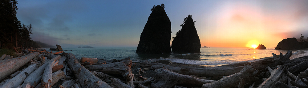
The coastal, rainforest, and alpine environments of the park can appear to be worlds apart. Yet, a bird flying over this landscape can leave the seastacks of the foggy Pacific coast, fly over the thick canopy of a voluptuous rainforest, and arrive at the jagged peaks of the Olympic Mountains in a mere 30-mile-flight.
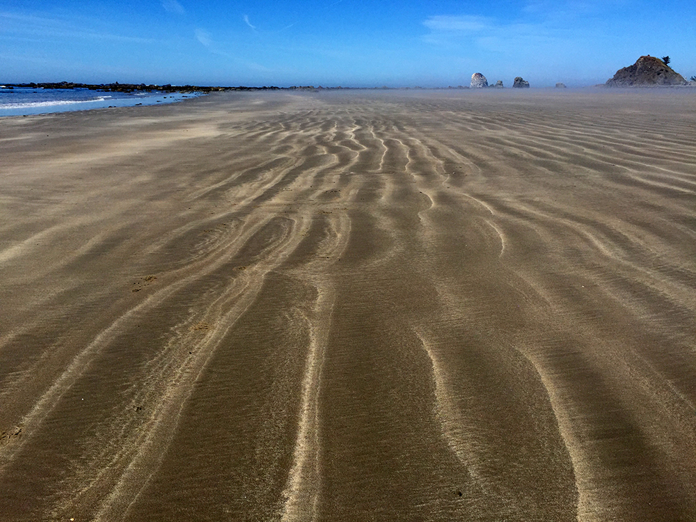
Pacific Coast
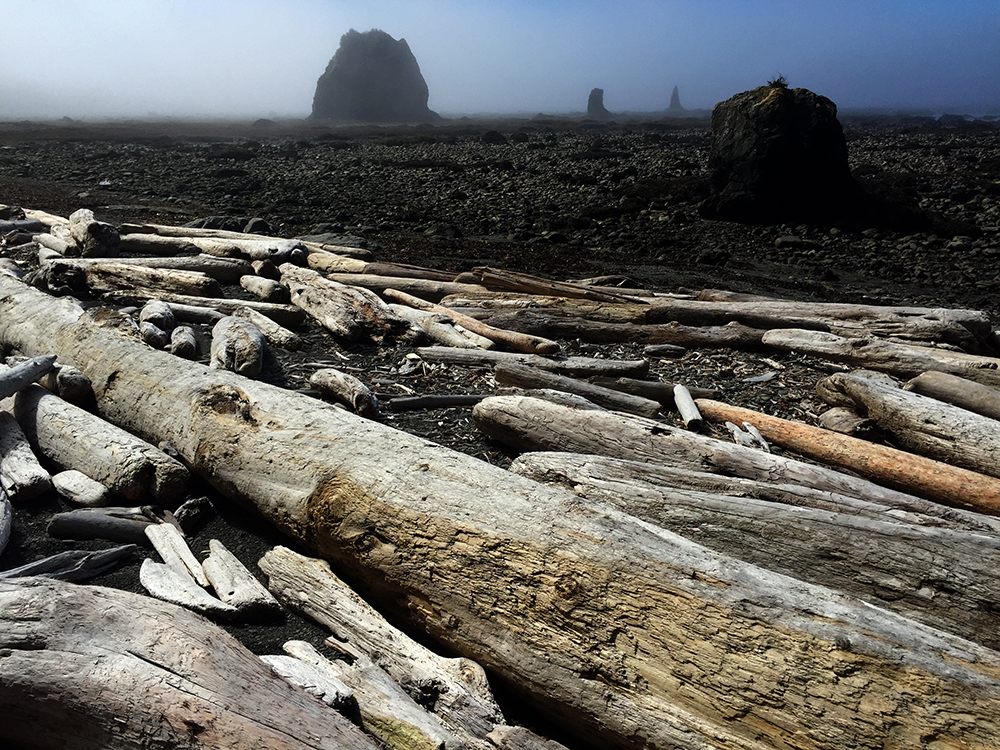
Olympic National Park is home to an absolutely stunning 73 miles of Pacific coastline. Along its beaches, eerie vegetated sea stacks seem to tease reality when viewed through lenses of foggy grey seas. The incessant crash of waves washes worldly concerns from the mind of the beach-combing visitor on this enchanting shoreline.
If seen under the right foggy conditions, this is quite simply, some of the most surreal coastline one can imagine.
Rainforest
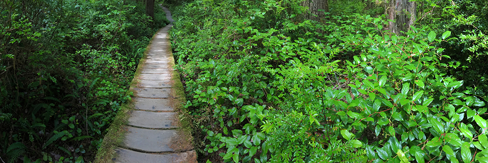
Slightly inland from the coast lie the modern remnants of what was once the largest temperate rain forest in the world. Although now merely a fraction of its original size, more than 366,000 acres of old-growth forest still remain.
The scenes held within are nothing less than mesmerizing. Massive trees cradle an abundance of mossy airborne life in their large sky-bound limbs. The forest floor is a literal sea-of-green without a single inch of bare soil to be found. Plant life here is supercharged by a constant climax and an abundance of moisture.
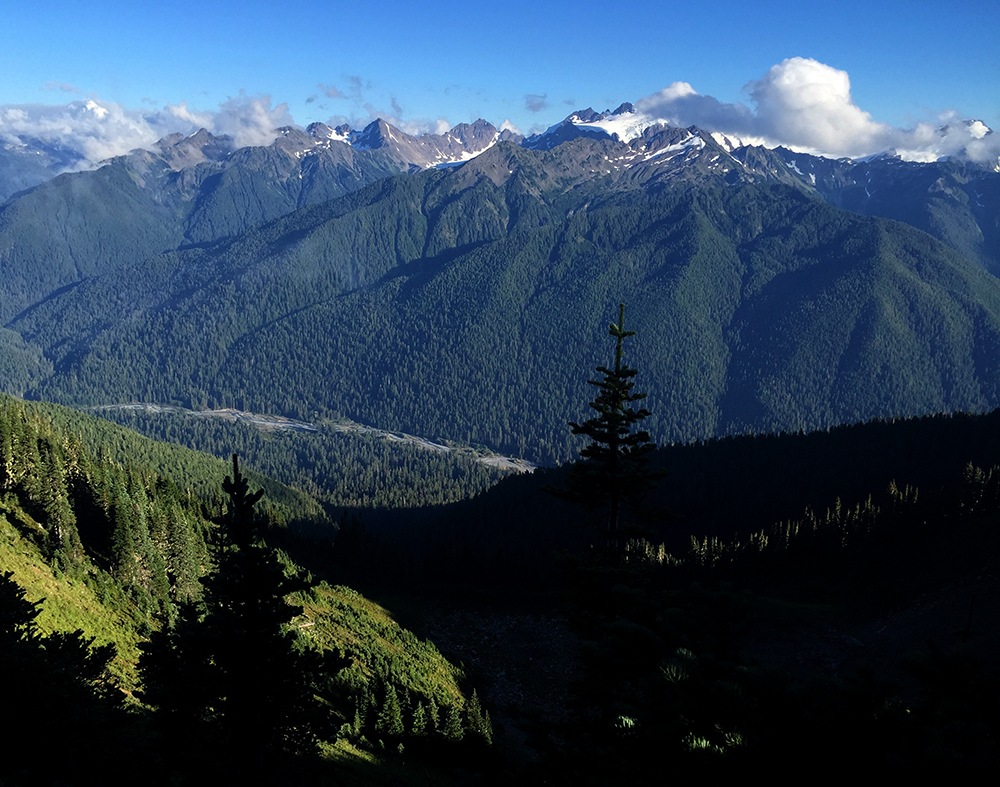
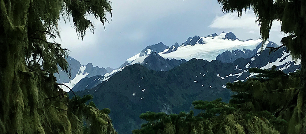
Alpine Peaks
Further inland, a rugged collection of alpine peaks holds jagged ridges and spiked mountaintops along with more than 180 active glaciers. This impressive number of glaciers is capped by Blue Glacier. At 900 feet thick and some 2.6 miles in length is the largest glacier in the park. Those prone to summit fever and glacier travel in its various stages of severity will find adventure aplenty here.
Topped by 7,980′ Mount Olympus, these mountains intercept weather systems moving eastward from the Pacific Ocean. The peaks extract record amounts of moisture from passing clouds. Gravity then distributes this lifeblood into the unique ecosystem that is Olympic National Park.
Exploring Olympic
At 922,000 acres, this is a large national park, the 13th largest in the national park system and the 6th largest in the lower 48. The park’s interior is difficult to access for casual visitors as long hiking trails offer the only route to the remote central areas of the Olympic range.
The variety of terrain and the absence of roads into the heart of the park can make this park seem even larger than it actually is. The roadway system here is perhaps best visualized as a wagon wheel, with spokes that never quite reach the center. A highway leads around the eastern, northern, and western sides of the park, while 12 smaller spur roads lead into the park’s interior. However, none of these connect with another.
Most visitors will be arriving from Seattle and driving into Port Angeles on Highway 101. Port Angeles is the largest community on the peninsula and is home to the park headquarters, as well as a wide array of services. Most anything you’ll need can be acquired here.
Once in town, the first move may likely be a swing by the Olympic Visitor Center on Mount Angeles Road. This location is also home to the Wilderness Information Center, where backcountry permits can be acquired. There are other such offices around the park, see the visiting page for a link to these offices.
We’ll take a quick tour below, and provide a brief description of the areas a traveler will encounter on a counter clockwise drive around the park on Highway 101, beginning just east of Port Angeles, at the Deer Park Road.
Deer Park
The Deer Park Road departs Highway 101, just east of Port Angeles and leads south to the park boundary, where the pavement ends. From here, the road continues upward into the mountains for 9 miles before ending near the summit of Blue Mountain, at just over 6,000 feet.
The area may seem strange compared to the park’s western forests, and indeed, it is. Deer Park sits in the rain shadow of the taller Olympic Mountains, and therefore receives a mere 18″ of annual precipitation. Compare this to the 150″ that are received in the Hoh forest and the 220″ of annual accumulation in the heights of the Olympics, and it is easy to see why the area seems a bit different.
A few hiking options are found here, and those with adequate route-finding and map reading skills can hike a 15-mile loop that leads to Obstruction Point, Grand and Goose lakes and across Grand Pass before connecting with a couple of other trails that lead back to Deer Park.
There is a ranger station here, but it is staffed only intermittently during the summer months. The road is steep and narrow, and will not be open during the winter months.
Hurricane Ridge
To the south of the visitor center, the Hurricane Ridge Road splits off to the right, and heads up and into the mountains above. This 17 mile drive leads as far into the park as any road is likely to take you and provides the easiest access to the park’s mountain regions.
The winding road is steep, and is open throughout the summer months. During the winter, the road is only open on weekends, holidays and is closed during inclement weather.
Numerous viewpoints along the drive provide spectacular scenery and at the end of the road, the Hurricane Ridge Visitor Center offers information and exhibits explaining the area’s natural features. A number of trails can be accessed from the Hurricane Ridge area that provide access into the heart of the park. See the activities page for a complete list of the park’s trails.
For those who can’t get enough of the high ridge scenery, try a drive out the Obstruction Point Road, an unpaved road which leads to a trailhead for Elk Mountain. At only 6,764′, this peak may not sound like a summit in the skies, but hey, Mount Olympus is only 7,980′, and Elk’s summit provides a great 360º view.
Elwha
Not often does the environmental community have an opportunity to celebrate the removal of a dam. But that’s exactly what happened here in the Elwha Valley, as two dams that were built in the early 1900s were removed during a three-year project that ran from 2011-2014 in one of the largest ecosystem restoration projects ever undertaken by the NPS. In fact, the project was the largest dam removal in U.S. history.
Prior to the construction of these dams, the Elwha was the largest watershed on the Olympic Peninsula, and was home to an incredible run of returning salmon each fall. With the construction of these dams, the salmon could not retrace their route homeward, and their populations in the Elwha River were decimated due to the dams and the resulting temperature changes in the river.
Scientists were cautiously optimistic about the return of salmon once the dams were removed. Immediately upon the dam removals, they implemented a revegetation project, both on the river banks, and on the lake beds, in an attempt to return the habitat to its natural state.
The removal of the dams provided access to more than 70 miles of spawning habitat that had been blocked for nearly a century. Amazingly, within months, salmon began to return to the river. Monitoring stations reveal that of the five Pacific salmon species, Chinook and Coho are thriving and regaining a hold in the river’s upper waters. Other species, such as Pink and Chum salmon seem to be struggling, but are showing signs of a slow return.
Today, the route into the Elwha Valley beyond the Madison Falls parking area is blocked, due to flood damage that has yet to be repaired. The road is open to bike and pedestrian traffic, but there are limited parking spaces and no services.
The Elwha Valley is home to some of the park’s better hiking, and the river is great for fishing and rafting. The Olympic Raft and Kayak Company offers rentals and guided trips. See the activities page for information on the opportunities available on the Elwha.
Lake Crescent
Lake Crescent is gorgeous, and you’ll know it when you see it. The lake is situated about 18 miles west of Port Angeles on Highway 101, which runs along the lake’s southern edge for about 10 miles. A number of pullouts provide lake access and a few spur roads lead to lodging and camping options.
Popular swimming areas include East Beach, Devil’s Punchbowl or Fairholme, and a small number of hiking options, including the 5 mile trek to Storm King, exist in the vicinity of the lake. The Crescent Lake Lodge and several other lodging opportunities are available, as well as a couple of camping options.
See the visiting page for lodging and camping options, or the activities page for recreational options.
Sol Duc
A definite must visit for the hot springs junkies among us, the Sol Duc area offers great hiking and camping in a lush mountain valley, complete with waterfalls and rushing waters to sooth your weary soul. I make sure to visit Sol Duc on each visit, just for a soak after beating myself to pieces on the park’s wicked trail system. The Sol Duc Hot Springs Resort provides a massive pool and three different fountain like tubs, each with varying temperatures.
The area offers a campground, a resort with lodging, a restaurant and of course the hot springs, not to mention a collection of trails that lead from Sol Duc into the spectacular backcountry of Olympic National Park.
A quick 1.6 mile hike from the trailhead at the end of the road leads to the incredible three-legged Sol Duc Falls, which is worth a few epic pics. For those who want a bit more, or for the backpackers, the Seven Lakes Basin is accessible from here, as is Bogochiel Peak, which provides a stunning view of the Olympic Range, which rises to the south, just across the Hoh River.
Ozette
The Ozette area is a remote region of the park that should be near the top of your list of places to see in Olympic. Located in the extreme northwest corner of the peninsula, this section of coastline is absolutely stunning.
It will take a little bit of effort to reach the Ozette, as it is quite removed from the remainder of the park. But a relaxing drive northward on Hwy 112 and a right turn on the deserted Hook-Ozette Road leads to Ozette Lake, the third largest lake in Washington, as well as a small campground and ranger station.
The campground is nice and quiet. The lake is tranquil and I’m told the fishing is good. But the main reason I always come all the way out here is to embark on the 9-mile Ozette Triangle hike. See the activities page for a description of this fabulous hike, which Park Junkie makes sure to schedule on each of his visits to Olympic.
Mora & La Push
This is another coastal area that offers amazing scenery, pounding waves and bizarre seastacks that rise from foggy seas. Mora and La Push lie separated by the Quillayute River, which renders the area an especially ripe for fish and bird encounters. Just inland from the shore, lush green forests hold towering trees that reveal the origins of the massive drift logs that line the coast.
This is the home of Rialto Beach, a popular beach combing area that offers beach camping with a backcountry permit and a 2 mile hike to the north. Camping among the massive drift logs and watching the sun set between the seastacks provides a memorable experience.
To the south of the Quillayute River are First, Second and Third Beaches. First Beach is located within the Quileute Indian Reservation and can be accessed by car. Second and Third Beaches require a hike, and are well worth the effort. I’m especially fond of Third Beach, and the hike to its shores winds along the coast, among giant trees that offer great protection from the incessant rains that provide such lush greenery.
Hoh Rainforest
Now this is one of Olympic’s must see areas. There is nothing quite like the Hoh, in all of our national parks. This place is a garden of green, as the 150″ of annual rainfall bless the landscape with lush blankets of mosses and ferns that cover anything in sight. Hikers must walk quickly when visiting the Hoh, or risk coming out with moss growing on their shoes. Kinda kidding there… kinda not.
The Hoh offers a few hiking options that provide access to the thickest forests in our parks. Several short trails, such as the Hall of Mosses and the Spruce Nature Trail lead through old growth forests of maple that stand draped in club moss, while the Hoh River Trail leads upstream, running parallel to the Hoh River for nearly 19 miles before ending at the Blue Glacier and the base of Mount Olympus.
The Hoh Visitor Center can be an excellent source of information when here, and the 72 site campground makes a great home base for exploring the area.
Ruby Beach & Kalaloch
Located on the park’s southwest coast, this area is one of the most visited in the entire park. The beaches are easily accessed and Ruby Beach is perfect for a typical “day at the beach”.
Don’t be fooled however, there is nothing typical about the scene here. Bald eagles and a number of other coastal birds often can be observed hunting or nesting along the shore. The tidepools of Kalaloch provide habitat for abundant populations of sea anemones and starfish, which can be found at during explorations at low tide.
The Kalaloch and South Beach Campgrounds offer oceanside accommodation and the beachfront Kalaloch Lodge is a nice option if you want that real bed sort of sleep. See the visiting page for more information concerning these options.
Queets
This is a quiet area in the southwestern corner of the park, which offers no services aside from a small primitive campground and a couple of boat ramps. An 11-mile unpaved road leads to the remote region, and the unimproved nature of the services here lend the visitor a degree of privacy that are may seem unique to Queets.
There are a couple of hiking options here, including a 3 mile loop, and a 16 mile one-way trek into the depths of the Olympics via the Queets River Trail.
Quinault
For those who arrive from the south on Highway 101, Lake Quinault, the surrounding rainforest and a small park community will serve as the first introduction to Olympic. That’s not a bad way to enter, as this location offers a good example of the scenery found in other areas of the park.
The Quinault Rainforest is quite similar to the Hoh Rainforest, and harbors harbors a number of record setting trees as well as a number of trails that access these trees. A few longer trails lead to remote lakes and alpine meadows, as well as the heart of the Olympics Mountains via Low Divide or Anderson Pass.
The area has two campgrounds, as well as the Lake Quinault Lodge, which was built in 1926, and offers that warm rustic lodge feeling. Its place on the National Register of Historic Places suggests that visitors take some time to look it over. At least take a minute to chill in the large lawn in front of the lodge and enjoy the view.
Staircase
Now we make our way to the park’s southeastern corner, which is quite removed from the southwestern corner, as no roadway exists to connect the two via direct means from west to east. A circular drive around the park requires a southward drive to Washington Highway 8, which runs from Aberdeen to Olympia, where the 101 begins its northern route back around the park.
Staircase is a small, remote area that offers no services aside from primitive camping and a small number of hiking trails that follow the North Fork of the Skokomish River and lead into the park’s backcountry. There is a ranger station here as well, but it is open intermittently in the summer. The gate to the location may be gated during winter months. Contact the park for information regarding the status of Staircase during the time you intend to visit. The park’s phone number is listed on the facts page.
All that Rain…
The wettest areas of the continental United States are found in the park’s four rainforests. The Quinault, the Queets, the Hoh, and the lesser known Bogachiel Rainforests collect in excess of 150 inches of rainfall annually. The Olympic Peninsula averages more than 200 days of rain per year. Forks, Washington, near the gateway to the Hoh Rainforest, is the wettest town in the US. It receives more than 120 inches of rainfall annually.
All this rainfall combined with the mild year-round temperate climate allows a great diversity of flora and fauna to proliferate here. Winter temperatures are not too cold and the summer temperatures are not too hot. This creates a perfect environment for variety of plants and animals. The temperate rainforests of the Pacific Northwest produce about three times the biomass (living or non-living organic material) of tropical rainforests.
There are numerous trails that allow up-close inspection of the rainforest environments. The most popular is in the Hoh Rainforest, which is probably the most spectacular and the easiest to explore for the casual visitor. This is also the trailhead for the Hoh River Trail which leads to Glacier Meadows, the most direct route (18 miles one-way) to the heart of the park and views of Mt. Olympus.
Park History
The land that makes up ONP today was first protected by our man TR in 1909 as Olympic National Monument. The purpose for its preservation was not the landscape, but the elk.
Roosevelt, an avid hunter, hoped to provide a sanctuary for the peninsula’s elk herds, whose numbers had been estimated to have dwindled to less than 150 due to hunting in the 1800s. Today, these elk bear his name as the Roosevelt Elk and their presence in ONP comprises the largest unmanaged elk herd in the NPS system.
Despite the land’s designation as a national monument, logging interests in the area continued to cut the valuable timber that stood inside the park long after 1909 and thanks in part to the war efforts of WWll.
Park Junkie Verdict
This park will definitely take several days to visit even if you only wish to hit the more popular areas because of the size and distance from place to place. A fast-paced visit that includes a few hikes and a beach session can easily take three or four days, and if you really want to see this place, a week is likely necessary.
As I said initially, this is one of my top parks! I simply have a blast every time I’m here. There are so many options for adventure in Olympic, and the simple variety of terrain available here is off the charts.
From the forests to the beaches, and from the beaches to the mountain tops, there is no limit to the smiles on your face when crushing the wilderness miles in this park… It is simply surreal.
So yeah, I’ll definitely see ya there…!
Guide to Olympic
Relevant Links
National Park Guides
All content found on Park Junkie is meant solely for entertainment purposes and is the copyrighted property of Park Junkie Productions. Unauthorized reproduction is prohibited without the express written consent of Park Junkie Productions.
YOU CAN DIE. Activities pursued within National Park boundaries hold inherent dangers. You are solely responsible for your safety in the outdoors. Park Junkie accepts no responsibility for actions that result in inconveniences, injury or death.
This site is not affiliated with the National Park Service, or any particular park.