Southern California’s Joshua Tree National Park teases visitors with strange little trees and otherworldly terrain reminiscent of a fabled far-away land from a Dr. Suess book.
Guide to Joshua Tree
Joshua Tree National Park
Situated in the arid landscape of southern California, Joshua Tree National Park is the meeting place of two distinct deserts, the Mojave and the Colorado. The park holds lands ranging in elevation from 500′ to over 5000′. Such diversity in elevation translates to extreme diversity in flora and fauna. The park is home to more than 800 species of plants that exist in an arid desert land where the odds are perpetually stacked against them.
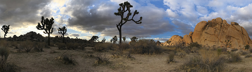
Here, the land is littered with strange little “trees” which Mormon pioneers thought to resemble the biblical Joshua with arms outstretched toward the heavens. In actuality, these “trees” are of the Yucca family of cacti and although they are found throughout the southwest, a great many seem to be right at home in J-Tree. They co-habitate with ocotillo, cholla cactus, creosote and of course, the silent jumbles of rounded red rocks that give this land a flavor all to itself.
Where is Joshua Tree?
Joshua Tree National Park is located in southeastern California, about 160 miles due east of Los Angeles, and just east of Palm Springs, to the north of Interstate-10. The park has three main entrances, which are easily accessed from I-10 or Ca. Hwy 62.
Most visitors enter the park from the northwestern corner through the town of Joshua Tree, which is about 30 miles east of Palm Springs, on Ca. Hwy 62. Another option is to continue east on Ca. 62, and enter the park at Twentynine Palms. Other visitors will access the southern entrance from I-10, about 65 miles east of Palm Springs.
Exploring Joshua Tree
Joshua Tree is a large park, covering nearly 790,000 acres. Most of the park is extremely remote and the desert landscape does little to foster easy access to much of the park’s out-of-the-way scenery.
The most popular and easiest areas to explore are found in the northwestern corner of the park. Visitors to this area travel on the 25-mile-long Park Boulevard, which is the main road that leads from the Twenty Nine Palms entrance, through Hidden Valley to the West Entrance State, just south of the town of Joshua Tree. The Pinto Basin Road runs northward from the Cottonwood Entrance at the park’s southern border. It meets Park Boulevard just north of the Belle Campground.
Numerous methods for exploring the park’s backcountry exist and include the ability to travel into the unknown via vehicle on a system of 4×4 roads that wind through the desert lands. Street-legal enduro style motorcycles are welcomed on these roads as well as mountain bikes. Please stick to the roads however, as off-trail travel by wheeled machines is strictly prohibited and damages the fragile terrain.

Queen Valley
Queen Valley holds a piece of everything that is Joshua Tree. There are mining ruins, archeological sites, cool hikes, fabulous views, and oh yeah, Joshua Trees.
The area sits just north of Park Boulevard, pretty much in the center of the park. A couple of short, unpaved roads run across the valley and provide access to one of the largest concentrations of Joshua Trees in the park.
Hiking trails in this area lead to the Desert Queen Mine, as well as the Wall Street Mine and Lucky Boy Vista.
Hidden Valley
Most visitors find their way into Hidden Valley at some point during their visit. This is another central location that has a number of attractions, including a litany of wicked cool rocks, and of course, Joshua Trees.
Speaking of rocks, Hidden Valley lends access to an area known as the Wonderland of Rocks. This collection of bizarre rocks lies to the north of the Hidden Valley Campground, and stretches all the way to the Indian Cove Campground near the norther boundary of the park. Trails such as the Barker Dam Nature Trail give a glimpse of the terrain. A more involved hike would be the Boy Scout Trail, which skirts the western edge of the Wonderland.
One of the most popular ranger-led activities in the park is found in the Hidden Valley area. A 90 minute guided tour of Keys Ranch is a great way to spend a couple of idle hours in the park. William Keys and his wife Frances raised 5 kids here, and operated their homestead from 1917 to 1969. Many of the ranch workings are still standing, and the surrounding area remains littered with mining equipment and old cars and trucks from a by-gone era.
The Hidden Valley area also features the ruins of Ryan Ranch, a late 19th century ranch that today consists of an adobe bunkhouse, windmill and cemetary. To the east of the ranch, a 3-mile-climb to the summit of Ryan Mountain treats hikers to a panoramic view that reveals the intricacy of the park’s central landscape.
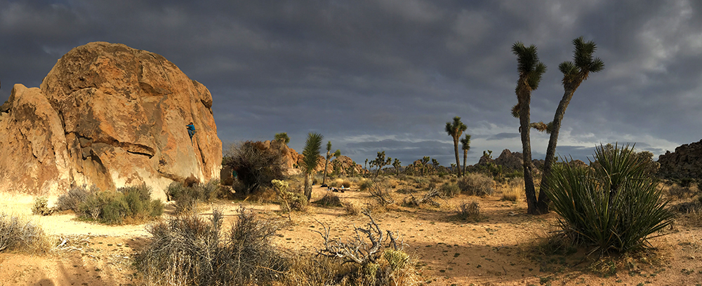
The Hidden Valley Campground is often temporary home to legions of the fabled dirtbag climbers, as the areas cliffs are world-famous for their challenging climbing routes and the perfect desert climate makes it easy to just pull your van into a spot and stay a while.
Keys View
To the south of the Hidden Valley, a paved road leads to one of the most prominent views in the park. Keys View is nestled among the Little San Bernardino Mountains and provides a perspective that looks out over the Salton Sea and the San Andreas Fault. This popular viewpoint is a don’t miss.
Covington Flat
This lightly visited area features a number of dirt roads that lead to scenic overlooks and some of the largest junipers, pinyon pines and Joshua Trees in the park. This location is accessed by its own entrance on the La Contenta Road, to east of Yucca Valley, near the park’s northwest entrance.
Black Rock Canyon
Tucked neatly out-of-the-way in the northwestern corner of the park, the Black Rock Canyon area offers a slightly different scene than is found along Park Boulevard. The rolling hills of this region provide habitat for piñons, junipers and even oaks. There are a number of short trails, as well as the California Riding and Hiking Trail that can whisk visitors into the surrounding hills.
The Black Rock Canyon Campground offers a place to call your own and the Black Rock Nature Center, which is situated in the middle of the campground, can provide books, nature guides and information.
Cottonwood Spring
Located just to the north of the park’s southern entrance, the Cottonwood Springs area stands apart from the surrounding landscape thanks to its leafy cottonwoods and towering fan palm trees, which seem weirdly out of place in the stark desert landscape of Joshua Tree.
Indeed, these trees only exist in this area thanks to an underground spring that provides the water necessary for their thirsty roots to sustain life in this brutal environment. There are a couple more such areas in the park. Hikers can access the Lost Palms Oasis, which lies about 3 miles to the east of Cottonwood on the Lost Springs Oasis Trail.
The Cottonwood Springs Visitor Center services this area of the park, and the Cottonwood Campground provides a nice perch for night sky viewing while camped in the park’s southern region.
Playtime in Joshua Tree
The park offers hiking trails that range from easy boardwalks of a mere 1/4 mile, to trails of more than 30 miles in length, one-way. There are numerous options for day hikes or backpacking trips and J-Tree is a great winter destination for such activities.
Horseback riding is available here as well, with more than 250 miles of equestrian friendly terrain waiting for you and your trusty steed. The two most popular areas for riders are Black Rock Canyon and areas near the west entrance to the park.
J-Tree is of course, popular in the rock climbing and slacklining worlds, and understandably so. More than 8,000 routes exist here as well as more than 2,000 boulder problems that offer challenge for beginners and seasoned veterans alike, while countless natural gaps keep the slacker community pacified. Climbing routes are most popular in winter as many other climbing areas are quite inhospitable in the colder months. Plan ahead.
The park offers numerous opportunities for camping, both from car and from backpack. See the Visiting Joshua Tree page for information regarding overnighting in the park.
When to Visit Joshua Tree?
Joshua Tree is open year round, although unlike many parks, summers are the least popular time to visit the park, as temperatures most often exceed the century mark.
Winters enjoy a nice climate, with daytime temperatures reaching into the 60sºF, however overnight lows can dip below freezing. Spring and fall are probably the ideal times to visit, as temperatures are mild, and these seasons lack the precipitation that can detract from a winter visit.
Wildlife in Joshua Tree
Several desert oases are found among the rocks and trees here, providing needed water for more than 250 species of birds as well as 44 species of reptiles and 52 species of mammals.
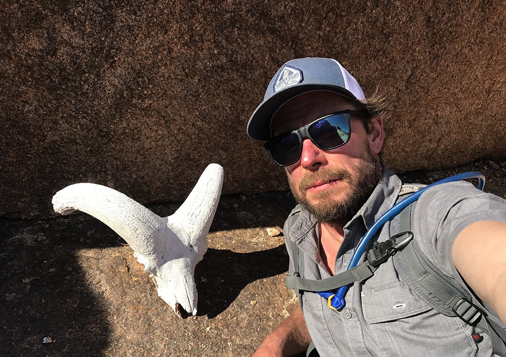
The number of bighorn sheep that occupy the park’s rocky terrain is substantial, but they fall prey to the silent mountain lions that lie in wait at watering holes throughout the park. Observant visitors may find the skulls of these sheep near such water sources. They are often small, indicating the victim’s youth, as the cats will target the weakest among the herd.
Park Junkie Verdict
Joshua Tree is a great winter destination for those seeking adventure in warmer climates when the would-be visitor’s homeland may be buried under ice. Summers can be downright brutal here, so consider the seasons when planning to visit this place.
Camping in the park provides a relaxing setting from which to base your adventures. I found the Hidden Valley Campground to be a friendly zone in which it was easy to find partners for the next day’s climbing adventure.
Joshua Tree’s hiking trails are often rugged, but assure relative isolation and unspoiled scenery and the rarely traveled miles of the park’s backcountry roadways are sure to take you away from anything that resembles the normal world.
See ya there…
Guide to Joshua Tree
Relevant Links
National Park Guides
All content found on Park Junkie is meant solely for entertainment purposes and is the copyrighted property of Park Junkie Productions. Unauthorized reproduction is prohibited without the express written consent of Park Junkie Productions.
YOU CAN DIE. Activities pursued within National Park boundaries hold inherent dangers. You are solely responsible for your safety in the outdoors. Park Junkie accepts no responsibility for actions that result in inconveniences, injury or death.
This site is not affiliated with the National Park Service, or any particular park.