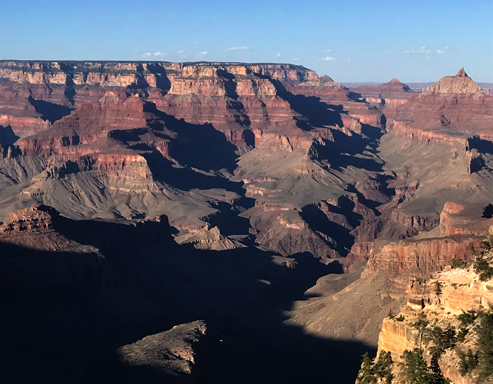
Relatively young in geologic speak at an estimated six million years old, the geology of the Grand Canyon provides broad insight into the Earth’s history. Many of our national parks include geologic wonders, but this is the only park that holds one of the seven wonders of the world…
Guide to Grand Canyon
A Living Textbook
Despite its youthful geologic nature, this intricate landscape exists as a living textbook from which scientists gather information that leads back to prehistoric times. The story of this natural wonder begins nearly 2 billion years ago, with a plate tectonic collision of massive consequence.
The Vishnu rocks found near the bottom of the Grand Canyon originate from a tectonic plate movement that merged a deep ocean trench and a number of volcanic islands, with the North American continent. Within this group of rocks are conglomerations of varying ages. The Elves Chasm is the oldest grouping, which some geologists separate, because it predates all other Vishnu rocks by 90 million years.
Formation of a Continent
The formation and stacking of rocks in this region began well before the shaping of the current landscape began some 250 million years ago with the breakup of the supercontinent Pangea. At this point, the landmass that would become North America began to separate from the northwestern coast of Africa, and eastern coast of Europe. Landscapes moved violently and periods of volcanic activity left their marks.
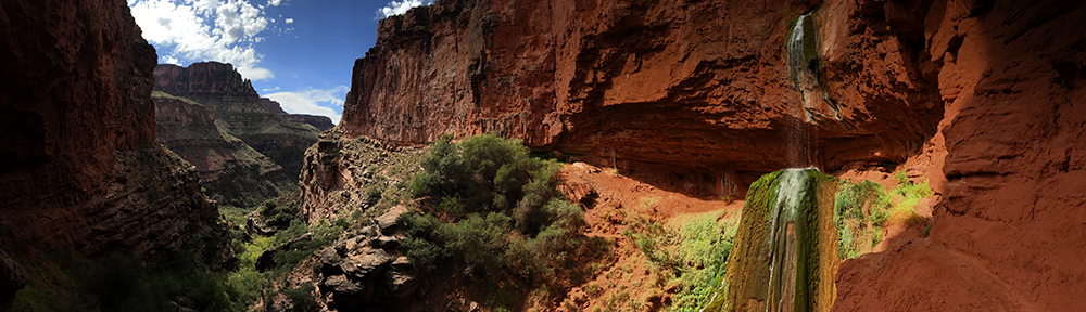
For part of our continent’s history, the region that today holds the Grand Canyon sat along the shoreline of what would become known as the Cambrian Sea. Shallow waters occasionally covered what is today the American southwest, depositing shells and remains from a vast array of marine life. Ripples from the Cambrian Sea can be seen in the rocks of the 545 million-year-old Tapeats sandstone layer, in the lower part of the canyon.
Sands from the Appalachian Mountains, far to the east were washed westward by rivers. Storms blew sands from these mountains toward the west, depositing thousands of feet of sand in massive dune fields in areas previously covered by seas. These fields were later covered once again by seas and by sands and by seas… another period of volcanic activity came… and went.. and the land once again became covered by sea… by sand… by sea… by sand… by sea… for a couple hundred million years.
Sands of Time
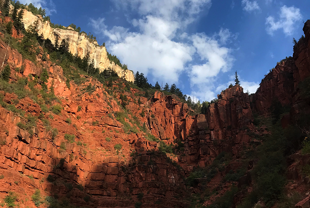
Important to the concept of the canyon’s formation is the principle of superposition. This is a geologic maxim which states that in a series of stratified sedimentary rocks, the lowest stratum will be the oldest, or the first to be laid down. Subsequent layers are stacked in order of age. By this definition, the rocks at the top of this stratum will be the youngest.
This principle is evident at the Grand Canyon, as the Kaibab Limestone that caps the canyon’s highest region dates to a mere 230 million years old, while the oldest Vishnu Schist dates to approximately 1.84 billion years.
Thousands upon thousands of feet of debris were collected in this area, stacking one layer of remains on top of another. Slowly, the lower regions were compressed by a combination of the unfathomable amount of weight above, and time…
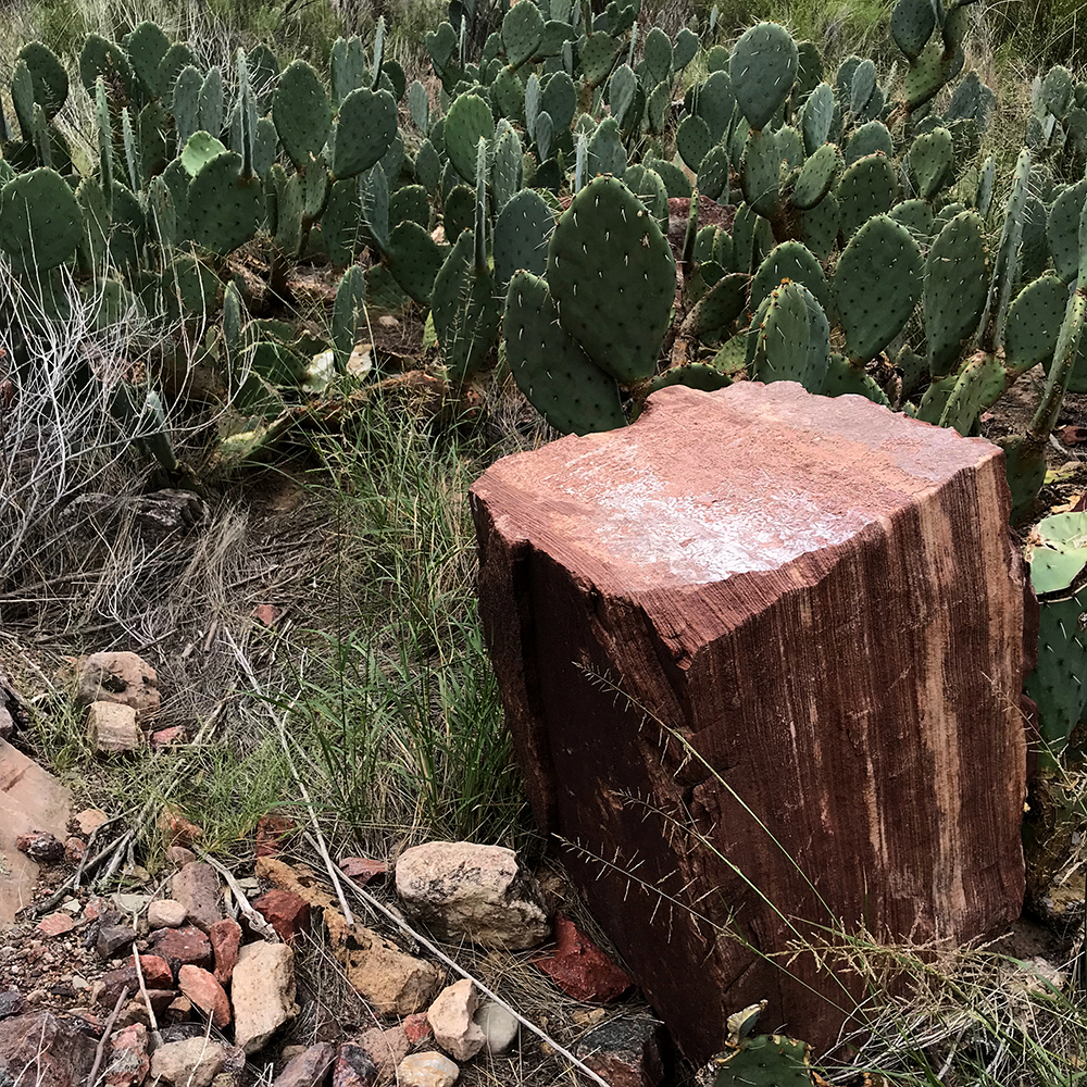
Sands and igneous stone were compressed and became uncommonly united. Remains of sea creatures fossilized and were sealed together by minerals and biologic process. More pressure was added by the weight of reoccurring soil distribution thousands of feet above. Sands became solidified and were ever-so-slowly turned to stone. Within 250 million years, a solid mound of earth was formed. It lay, silently buried below the surface of this land.
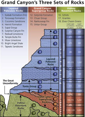
Grand Canyon’s Rock Layers
Initially, the scientific community divided the layers of the canyon into three main “sets”. The crystalline rocks of the Inner Gorge (Vishnu Basement Rocks), the tilted rocks of the Grand Canyon Supergroup, and the Layered Paleozoic Rocks in the upper two-thirds of the canyon. Today, scientists recognize nearly 40 separate rock layers that that form the walls of the Grand Canyon.
Public Domain Image*
Geologic study has improved with scientific advancements since the time of John Wesley Powell’s first journey into the depths of this land in 1869. Beginning in the 1870s, geologists began to study the geology of the Grand Canyon and to separate the layers of this great canyon, recognizing immediately that it held tales of long before. Powell himself termed the canyon’s walls “the library of the gods” referring to the amount of geologic information held in the canyon’s high reaching cliffs.
The erosion of this fascinating landscape has unearthed a treasure trove of geologic evidence. Studies here began in the mid 19th century and continue today. This is a unique land that offers opportunities to investigate numerous levels of history, all in one location.
Know The Canyon’s History, Study Rocks Made By Time
The Grand Canyon has many layers, but scientists have narrowed the most identifiable sections into about 40 stratified sections. The mnemonic phrase above aids in the memory of the most prominent of these layers found as one descends into the canyon.
Know – Kiabab limestone – 230 million-years-old
The – Toroweap formation – 255 million-years-old
Canyon’s – Coconino sandstone – 260 million-years-old
History – Hermit shale – 265 million-years-old
Study – Supai Group – 285 million-years-old
Rocks – Redwall limestone – 335 million-years-old
Made – Muav limestone – 515 million-years-old
By – Bright Angel shale – 530 million-years-old
Time – Tapeats sandstone – 545 million-years-old
The Great Unconformity
An observant student of this information may recognize a wide gap between the timeline presented above and the mention of a 1.8 billion-year-old Vishnu layer a few paragraphs back.
The Great Unconformity is a scientific oddity located deep in the Grand Canyon. Just below the Tapeats Sandstone layer lies the Vishnu basement rocks. If one examines the numbers of these stone layers, a wide gap occurs in the timeline. Wide enough to count to 1.2 billion years.
This gap in time was first recognized by the canyon’s original explorer and geologist, John Wesley Powell in 1869. Major Powell, as he wished to be called, realized that there was a significant time gap here, although he lacked the tools to accurately determine the ages of the rocks.
This layer of “missing time” is observed worldwide, but is openly displayed right here in the depths of the Grand Canyon. It appears that sediment or prehistoric remnants that were deposited here were either washed away, or were never deposited in the first place. This absence of material from such a wide period baffles scientists still today.
The Laramide Orogeny
Sometime around 70 million years ago, an uplift of significant consequence known as the Laramide orogeny began beneath the western coast of North America. This event was due to the movement of massive tectonic plates under the continent’s western coast. The smaller Pacific-born Farallon Plate was slowly being forced under the North American Plate in a process known in scientific circles as subduction.
Subduction zones are famous for producing really cool mountains and lands of jagged ridges and steep deformed valleys. The results of the Laramide orogeny are evident throughout the western mountain states. In fact, this period of faulting and folding gave birth to the Rocky Mountains themselves.
Colorado Plateau
The Grand Canyon today sits at the southwestern edge of a geologic province known as the Colorado Plateau. This formation is an exquisite piece of Earth, a scientific wonder that is home to 25 units of the National Park Service.
The Colorado Plateau is an uplifted region of the Earth that ranges from the Rocky Mountains of Colorado southward into New Mexico. To the west, it covers all of southern Utah and northern Arizona, terminating at the western edge of both states.
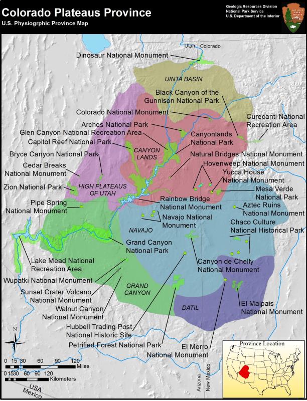
NPS Image
During the period of the Laramide orogeny, the lands that today hold the Grand Canyon remained relatively unaffected by the violent uplifts occurring a mere few hundred miles to the northeast. This remains a subject of curiosity for geologists.
The forces of subduction began to decrease about 40 million years ago, as the angle of the subduction began to steepen, effectively withdrawing its crushing effects to the west.
The Grand Staircase
The western edge of the Colorado Plateau constitutes an area known as the Grand Staircase. This region of the plateau includes Bryce Canyon, Zion and the Grand Canyon National Parks. The uncommonly preserved scale of rocks observed here is unparalleled on this planet.
A time-table of rocks stands visible in these parks, with the youngest atop the Paunsaugunt Plateau at Bryce Canyon. Moving downward, the bottom layer at Bryce is the top layer at Zion. Consequently, the bottom layer at Zion is as follows, the top level at the Grand Canyon.
The Colorado Plateau is comprised mainly of sandstone, with occasional layers of sedimentary and igneous rock riddled throughout. This is the land built by the shifting sands that were washed westward over the past two hundred million years. Sand that was then compressed by sea and more sand… and time.
How did the Colorado Plateau Form
The timing and the cause of the Colorado Plateau’s formation is not completely understood. Several theories attempt to explain how this area became elevated more than a mile from where it once lay, while maintaining the composure of the underlying landscape. The most likely may be the theory of isostatic rebound.
This theory contends that an area of Earth that is compressed will expand upon release of that compression. In this case, it follows that the Laramide orogeny exerted unfathomable forces upon the inland land masses of western North America, for thirty million years. The Rocky Mountains were formed by this event. While these forces did not act that extreme extent upon what would be the Colorado Plateau, they did compress neighboring lands significantly, including those of the future Colorado Plateau.
Upon release of these forces thanks to a steepening subduction zone, the pressures were released. In essence, as the pressure from the west was slowly released, the land lifted due to its newfound weightless nature. This allowed the land that was previously compressed to expand upward, without violent action. This action could be in continuation today according to some in the scientific community.
However, this is just a theory, and one of contention at that. There are others that attempt to explain this uplift. The theory of lithospheric attenuation, or increased heat flux due to post-Laramie extension. Or the theory of a buoyant crust in response to an upwelling of the Earth’s mantle beneath the plateau… We’ll just leave such heated arguments to the experts…
No matter the means by which this massive area moved skyward. The important fact is that its rocks are largely intact today. They are undamaged specimens of a prehistoric time. Thanks to whatever bizarre process is responsible, this geologic feature is considered one of the most intact landmass uplifts on the face of the Earth.
Formation of the Grand Canyon
Interestingly, once again, there are multiple theories concerning the formation of the Grand Canyon itself. There is some evidence to suggest that sections of the Grand Canyon began to form at the beginning of the Laramide orogeny, nearly 70 million years ago.
Some in the geologic community argue that the canyon we see today is the combination of several canyons which existed as parts of different rivers. Most such theories purport that geologic forces connected these rivers around 5-6 million years ago.
Runoff from the rising Rocky Mountains and the surrounding area had of course, been occurring since the beginning of the Laramide orogeny some 70 million years ago. Most scientists agree that the body of water we today call the Colorado River, once ran to the northeast. Topographic changes during the Laramide orogeny forced the river to change course. Surprisingly, the Colorado switched it up and began to run southwest somewhere between 60 and 15 million years ago.
Numerous theories contend to show the canyon’s origin with little proof. What is clear however, is that the magnificent Grand Canyon is nothing more than the result of millions of years of erosion on an arid landscape. This canyon is a product of the incessant flow of water and weather…
The Colorado Plateau stands as an elevated a mass of largely soft stone. The forces of nature initiated the processes of erosion as the plateau began to rise. Melting snowpack in the Rocky Mountains, and in the mountains throughout the Colorado Plateau sent runoff into the lower areas. There are three main reasons that this canyon was able to form in such a small amount of geologic time.
The Grand Canyon – A Young Canyon
The volume of the Colorado River is not large compared to say, the Mississippi or Ohio Rivers. With a flow of between 12,000 and 15,000 cubic feet per second (cfs), it is a fraction of the size of such bodies of water. By comparison, the Mississippi River has an average cfs of nearly 600,000 cfs and the Ohio weighs in at nearly 300,000 cfs.
The Colorado averages 300 feet across and 40 feet deep. During storms, its volume can increase rapidly from a meager 12,000 cfs, to a rate of more than 300,000 in a matter of minutes. Such storms and their flash floods rapidly remove monumental amounts of sediment from this desert land.
The arid southwest climate provides little in the way of plant-life, whose roots would hold sandy soils in place, and slow the process of erosion. Absent this beneficial plantlife, the barren soils of this region are easily washed into the canyon during violent storms. These particles of dirt and rock are then whisked away by the rushing waters below.
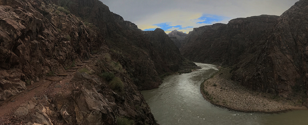
The Colorado River has formed a steep gradient in this area, dropping about 2,000 feet in 277 miles. The increased angle associated with such a drop provides a faster and more powerful flow of water that is able to move larger amounts of debris. This provides a quicker erosional effect than a slower moving body of water.
The Process Continues
The erosion continues today. Every second, the water flow is removing more sediment from the canyon. This moves the river ever-deeper into the bottom of the canyon. Rockfall from the weakened sandstone layers above fall due in part to the effects of frost wedging. Small amounts of water find their way into small cracks in the rock. There they freeze and expand, weakening the rock. After countless repetition of this process, the stones give way and fall into the river below. The river slowly carries them away.
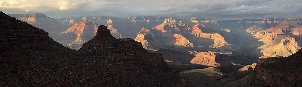
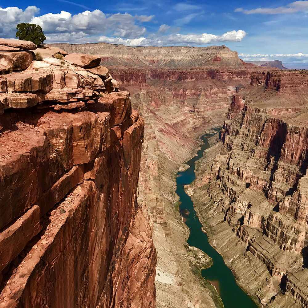
Today, the Colorado continues to act as a constant natural bulldozer. For the river, the Grand Canyon is little more than a large construction zone. The architect is gravity, but the river does the bulk of the work.
Just take a look. Sit atop the canyon rim and examine the scene before you closely. At just the right time of day, sometimes you can see the ol’ dozer at work far below. It’s there, plowing through the land with an unending appetite for beautiful destruction.
The small ribbon of water far below, constantly laboring on its masterpiece.
Guide to Grand Canyon
Relevant Links
National Park Guides
All content found on Park Junkie is meant solely for entertainment purposes and is the copyrighted property of Park Junkie Productions. Unauthorized reproduction is prohibited without the express written consent of Park Junkie Productions.
YOU CAN DIE. Activities pursued within National Park boundaries hold inherent dangers. You are solely responsible for your safety in the outdoors. Park Junkie accepts no responsibility for actions that result in inconveniences, injury or death.
This site is not affiliated with the National Park Service, or any particular park.