If you’re seeking solitude and stunning scenery in a far-removed red desert land, you need look no further than south-central Utah’s Capitol Reef National Park.
Guide to Capitol Reef
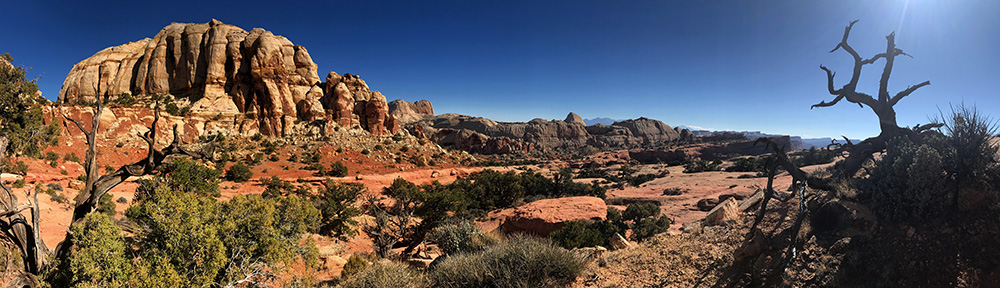
Capitol Reef National Park
Owing its landscape to the nearly 100-mile long Waterpocket Fold, the park’s dominating geologic feature, Capitol Reef offers visitors endless opportunities to explore little-known canyons, buttes and washes, as well as the intricately carved Hall’s Creek Narrows.
If you’re looking to escape all those damn people that are crawling around Zion Canyon, this park should probably be at least a stop-over destination. There are limitless remote areas of this park, where you’ll nary see a soul. Careful though, this means you’re on your own. This place is remote!
Where is Capitol Reef?
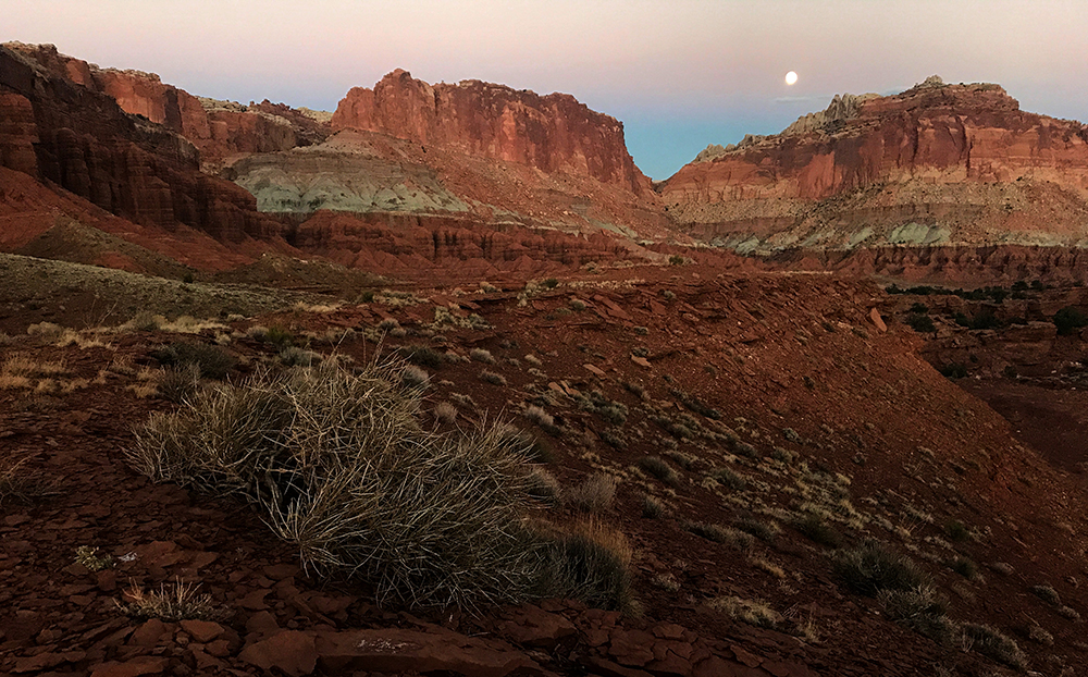
Capitol Reef National Park is located in south-central Utah. It is the middle child, location-wise, of the Beehive State’s Mighty Five National Parks, and sits between Bryce Canyon and Canyonlands. The park is long and thin, and stretches for nearly 100 miles from north to south along a geologic feature known as the Waterpocket Fold, which is a beautifully uplifted and strangely tilted section of the area’s classic red-rock sandstone.
Most visitors enter the park along Utah Highway 24. This scenic highway connects Torrey and Hanksville, with Capitol Reef’s jagged landscape providing a substantial obstacle to overland travel between these small towns. Luckily, the Fremont River long ago cut a wide path through the park’s massive sandstone cliffs and wise highway engineers decided to follow that route when constructing Hwy 24.
Exploring Capitol Reef
Although the park statistics may lull one into assuming that Capitol Reef is not all that large at just under 242,000 acres, it is incredibly intricate in its terrestrial composition. It is possible to spend a lifetime exploring this area, and only put a fairly solid scratch in its surface.
The Waterpocket Fold is a classic example of what geologists refer to as a monocline, essentially a massive wrinkle in the Earth’s crust. This was created by an uplift to its western side, which gave the entire feature a tilted incline that rises to the west.
The fold’s landscape is abruptly divided by deep, narrow canyons at nearly every corner, and elevations range from 3,800 to over 8,200 feet. Visitors can access these unique areas from a number of areas.
Fruita
The Fruita district is the social hub of Capitol Reef. Here you’ll find the Visitor Center, the Fruita Campground, the Fruita Orchards, numerous historic exhibits and a number of hiking trails. Just to the north of the highway, a petroglyph panel contains messages from native inhabitants, who predate the town’s formation by thousands of years.
Fruita was founded by Mormon settlers in the 1880s. While this desert oasis has hosted a continual flow of human occupation for thousands of years, the nineteenth century witnessed the development of a small community from which numerous relics remain.
The last residents left this area in 1969. Today a small schoolhouse, a blacksmith shop, and the classic Gifford homestead remain, along with the family’s barn and farmhouse, which dates to 1908.
You’ll undoubtedly want to check out the former kitchen of the Gifford House, which today acts as a small storefront, in which the Capitol Reef Natural History Association sells local, hand-made artisan goods, in addition to freshly baked pies and homemade ice cream!
Guests will certainly not want to overlook the fruit orchards either, which hold more than 2,500 trees that blow up with produce in the late summer months. Visitors can just head on out and pick their share of fruit from the well-manicured trees during season. Of course, there is a small fee for the fruit, and rates are posted at the entrance to particular orchards.
Scenic Drives in Capitol Reef
Lying just to the south of the visitor center along Hwy 24 and the Fruita District, the park’s eight-mile scenic drive is a must do for curious park visitors. The route leads into the heart of the park, and provides access to a stunning scenery of red cliffs that results with endearing looks of wonderment that come over visitors to Utah’s National Parks.
Two shorter dirt drives spur off of the Scenic Drive: Grand Wash and Capitol Gorge. Both of these routes are open to vehicular travel and can usually accommodate passenger cars, and even RVs of less than 27 feet in length. These routes may close at any time due to inclement weather, and visitors should never venture into these tight canyons if stormy conditions seem likely.
The 1-mile drive into Grand Wash leads to the trailhead for the Cassidy Arch Trail, which of course, was named for famous outlaw Butch Cassidy, who according to local legend, used this canyon as a hideout back in the late 1800s.
Further down the scenic drive, the Capitol Gorge road leads into its narrow namesake passage as sheer red walls rise to engulf eager motorists. This drive features many roadside petroglyphs, which were left by the Fremont Indians, who inhabited the area circa A.D. 600-1200.
It would be advisable for most motorists to turn around at this point, and return back to Fruita. However, for those who are driving a capable high-clearance 4×4, another option presents itself.
To the south of the scenic drive, the South Draw Road leads to the south, where it links to the Pleasant Creek Road, from which motorists can travel westward to meet up with Utah Hwy 12. This route is rugged, and is only recommended in good weather and for those with capable machines.
Cathedral Valley
Other driving options exist in the park as well, and they’re all exciting. The 60-mile Cathedral Valley Loop is an absolute favorite drive for scenery, and also requires a capable 4WD machine.
This unpaved route leads through the remote regions of the park that lie to the north of Hwy 24. The journey will require a couple of crossings of the Fremont River, so you’ll want to assure that a river crossing manageable before driving into the water.
Also, look at the weather forecast, cause you’ll need to cross it again on your exit, unless you plan to exit through a series of endless roads that lead to the north and Interstate 70… a long way away.
Those who head into Cathedral Valley will likely not forget the scenery. Features such as the Temple of the Sun and Temple of the Moon exists beside the Walls of Jericho and the strangely placed large black boulders that stand in stark contrast to the red and pink hues of the Utah desert.
A primitive campground is located along the route for those who wish to just chill for a day or two.
Notom-Bullfrog Road
Running the length of the park below Hwy 24, the Notom-Bullfrog Road is a classic Utah drive. This route connects the civilized world of Hwy 24 with the remote reaches of Capitol Reef’s southern boundary with Lake Powell and the Glen Canyon National Recreation Area.
This road is paved for the first 15 miles, before turing to dirt. From here, it runs south for what seems 100 miles, and if you’re driving north on the Notom with hopes of making it back to the pavement during a summer monsoon, it seems more like 1,000 miles. Ask me how I know…
The Notom Road parallels the Waterpocket Fold as it winds along low lying Strike Valley, which roughly constitutes the park’s eastern boundary. Along this route, backcountry campers will find the Cedar Mesa Campground, about 23 miles south of Hwy 24, as well as a number of pullouts and spur roads that lead to interesting hikes into side canyons.
Toward the southern end of Capitol Reef, the Notom Road leads up and out of Strike Valley and toward the remote Bullfrog Marina, on Lake Powell. Soon after the road’s exit from the valley, a small rugged 4×4 trail leads to the Hall’s Creek Overlook. This serves as the trailhead to the Hall’s Creek Narrows hike, which is a little-known remote highlight of this unique park.
Burr Trail
Rarely does Park Junkie venture into Capitol Reef that he does not take the Burr Trail to access at least a small portion of his adventures in the park. It is simply one of the coolest drives in Utah, which places it high in the running for coolest worldwide.
Originally used as a stock-driving route during the early days of Mormon settlement, this 70-mile route today runs from the small quaint town of Boulder, Utah, through the eastern section of the massive Grand Staircase Escalante National Monument, and into the southern region of Capitol Reef, where it drops some 800 feet in a series of switchbacks that will leave your grandmother aghast. After dropping down the face of the cliff, the Burr Trail meets the Notom Road, as if nothing had ever happened.
The road is paved from Boulder to the park boundary, where it turns to dirt, before dropping off the edge of the Earth at the aforementioned Burr Trail Switchbacks. The paved section offers good dispersed camping outside the park, and the Deer Creek Campground, six miles outside of Boulder, offers a few nice campsites tucked into the willows and Cottonwoods beside a flowing stream.
This route is used to access a couple of the park’s most stunning remote hikes: The Upper and Lower Muley Twists. See the Capitol Reef Activities Page for a description of these hikes.
Playtime in Capitol Reef
With a quarter million acres of untracked wilderness, Capitol Reef is a backcountry hound’s dreamtime playground. With a minimal amount of effort, the solitary adventurer can make their way into an unforgettable world where encounters with other humanoids is rare. In most cases in Capitol Reef, if you do happen to cross paths with another soul, they’re probably pretty cool.
The most popular trails in the park are understandably found along Hwy 24, or the Scenic Drive south of Fruita. From a stunning view at Hickman Bridge on the Rim Overlook Trail, to the further outreaches of the Navajo Knobs, or the high desert scenery of the Cassidy Arch, hikers will likely be content with any choice in this area.
For those willing to travel dusty dirt roads and winding switchbacks, adventures exist here that will undoubtedly thrill the soul. The hikes into the rugged backcountry along the Burr Trail or the Notom Road lead into some of the most remote terrain in Utah’s National Parks.
Backpacking excursions are one of the better ways to get to know the Capitol Reef backcountry, despite the fact that the common overlook in this park immediately displays its prowess in comparison with other parks.
Many of the park’s backcountry trails are friendly to horse travel, and a journey on your favorite steed into this western enclave will represent a true equestrian accomplishment. There are endless miles to enjoy as you trod along with the reins in your hand in this park. Don’t forget to plan for water… Here, you can lead a horse to water, and it will drink it!
Fort the canyoneering folk who happen to stumble into this pit, you’d be well-advised to just get after it or stay at camp. There are canyons in this park that have likely still not been explored, so you’ll want to call your mom and let her know that you love her before you head in…
Park Junkie Verdict
This park is remote and rugged. Most of it’s adventures require immense preparation, much like many other parks, but for those who thirst for crowd-free, extreme desert adventures, this is probably what you’ve been looking for…
I’ll be quite honest here. This is my favorite Utah park, aside from my homeland of Zion, of course. I somehow always find myself heading out to Capitol Reef in order to escape the masses and to simply enjoy the art of wilderness.
I found Capitol Reef in 1999, when I passed through accidentally on my way to Bullfrog to visit a friend who worked at Bullfrog. I had actually never heard of it.
This was prior to cell phones and online maps, so I was following the good ol’ Rand McNally Road Atlas. There was a green area here, with a national park designation, but not much info was available other than that. I was in a hurry to get to my buddy before sundown for cold beers on a boat. I was late….
Well, the red cliffs along the Fremont River captivated my gaze and I was forced to pull over. I stayed for a while and gawked at the scenery, and I ended up arriving at the Bullfrog docks with not a second to spare…
I didn’t forget the stunning scenery, and returned to Capitol Reef less than a year later, after moving to nearby Zion National Park. I headed down the Burr Trail, not having a clue what scenery was held in that region. I found the Lower Muley Twists, and had one of my best days ever.
A lifelong love affair ensued with this land, and I make the pilgrimage to this park at least twice per year. You’ll probably come across my tracks out in the canyons of the Waterpocket Fold, as I just can’t stay away.
See ya there…
Guide to Capitol Reef
Relevant Links
National Park Guides
All content found on Park Junkie is meant solely for entertainment purposes and is the copyrighted property of Park Junkie Productions. Unauthorized reproduction is prohibited without the express written consent of Park Junkie Productions.
YOU CAN DIE. Activities pursued within National Park boundaries hold inherent dangers. You are solely responsible for your safety in the outdoors. Park Junkie accepts no responsibility for actions that result in inconveniences, injury or death.
This site is not affiliated with the National Park Service, or any particular park.