
The topography of this park is among the most unique in our park system and the geology of Bryce Canyon is quite fascinating. The collection of hoodoos displayed here is the largest and densest in the world. Their position on the edge of the Paunsaugunt Plateau offers the opportunity to investigate these structures and the processes that created such a marvelous display of nature’s artistic ability.
Guide to Bryce Canyon
The Colorado Plateau
Bryce Canyon National Park today sits in the southwestern region of a geologic province known as the Colorado Plateau. This formation comprises more than 130,000 square miles of incredibly bizarre landscapes and is home to 25 units of the National Park Service.
During the period of the Laramide orogeny which began some 70 million years ago, the lands that today hold Bryce Canyon remained relatively unaffected by the violent uplifts occurring a mere few hundred miles to the northeast. This remains a subject of curiosity for geologists.
The forces of subduction began to decrease about 40 million years ago, as the angle of the subduction began to steepen, effectively withdrawing its crushing effects to the west.
Bryce is the highest of the national parks located upon the Colorado Plateau and thus, a study of the geology of Bryce will show that it is unique among Utah parks. Its elevated position ranges between 6,000′ and 9,100′. This lends the park a climate of its own and a landscape that is unique among its neighboring parks.
Scientists estimate that this area was covered by an ancient sea some 50 million years ago. Lifeforms in this sea died, and fell to the floor where they were preserved in layers of muck and ooze. Over time, these layers were compressed into what we call a type of sedimentary rock, or limestone. The layer of rock that forms the cliffs of Bryce Canyon is the top layer of rock found in the Grand Staircase. This layer is known as the Claron Formation.
That rock was slowly buried. In many places it was mixed with sand and other minerals, but in what is today Bryce, it remained largely unaffected by alien elements. When the Colorado Plateau was uplifted some 20 million years ago, these layers of stone were exposed to the weathering process.
The Grand Staircase
The western edge of the Colorado Plateau constitutes an area known as the Grand Staircase. This region of the plateau includes Bryce Canyon, Zion and the Grand Canyon National Parks. The uncommonly preserved scale of rocks observed here is unparalleled on this planet.
A time-table of rocks stands visible in these parks, with the youngest atop the Paunsaugunt Plateau at Bryce Canyon. Moving downward, the bottom layer at Bryce is the top layer at Zion. Consequently, the bottom layer at Zion is as follows, the top level at the Grand Canyon.
The Colorado Plateau is comprised mainly of sandstone, with occasional layers of sedimentary and igneous rock riddled throughout. This is the land built by the shifting sands that were washed westward over the past two hundred million years. Sand that was then compressed by sea and more sand… and time.
Frost Wedging
The primary factor responsible for the erosional patterns at Bryce Canyon is a process known as “frost wedging”. This occurs when water finds its way into cracks and crevices in rocks and dirt. The water freezes, which causes the water to expand by up to 10% its size. The expansion of that water weakens and perhaps enlarges cracks in that rock or dirt. Then the water thaws, and drains away. Any part of the rock or dirt that is loosened by this process may be washed away by the water on its way out. Maybe not that day, but some day such debris assuredly will fall or be washed away.
The elevation of Bryce Canyon provides temperatures that dip below freezing more than 200 nights per year. During the subsequent day, the brutal desert sun bakes the soil and rock, thawing any water frozen within. Thus, the freezing/thawing cycle repeats itself here more than 200 times per year. This may not seem significant, but multiply 200 by 20,000,000 and the numbers quickly become significant.
This process is aided by rainfall, which even here, is slightly acidic. This acid helps dissolve the limestone rocks and rounds the edges into soft, lumpy shapes that the natives believed resemble faces. The rains also wash away debris and clean the landscape.
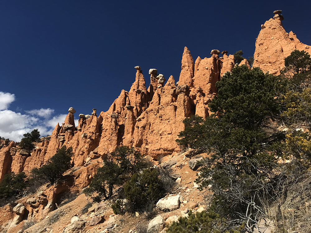
The layers of rock here alternate between hard and soft, with areas in which the harder rocks are found atop softer rock. Such is the case at the Hat Shop. The layers of rock found capping the weaker towers below actually work to protect their pedestal and prevent a more rapid erosion.
Despite their beauty, these geologic wonders, like all others, will not stand to the test of time. They will disappear just like the sandstone cliffs of other southwestern places of equal stature. Scientists estimate that the erosional forces that created these crazy towers will eat their way westward across the Paunsaugunt Plateau and remove all trace of the presence of the famous hoodoos. What will this place look like then…?
Guide to Bryce Canyon
Relevant Links
National Park Guides
All content found on Park Junkie is meant solely for entertainment purposes and is the copyrighted property of Park Junkie Productions. Unauthorized reproduction is prohibited without the express written consent of Park Junkie Productions.
YOU CAN DIE. Activities pursued within National Park boundaries hold inherent dangers. You are solely responsible for your safety in the outdoors. Park Junkie accepts no responsibility for actions that result in inconveniences, injury or death.
This site is not affiliated with the National Park Service, or any particular park.