The range of activities in New River Gorge National Park present a challenge for any potential visitor. Raging waters beckon river runners, while more than 1,600 established climbing routes await the competent climber.
Miles of wooded trail await the worn tread of seasoned hiking boots, trout restlessly await a shiny fly slung from an able rod and historic structures hold lessens for the astute scholar of Appalachian history.
Guide to New River Gorge
Hiking in New River Gorge
New River Gorge National Park offers an excellent selection of hiking trails that lead to stunning vistas and views of the ancient river far below. A few trails wind along the river itself, while providing access to long-forgotten industrial structures which somehow act to enrich the park experience in a historical sense.
The trails at New River Gorge vary in length and difficulty. Some short paved loops provide a nice place to take grandma for an afternoon stroll, while others require that hikers lace up their shoes and get after it. Whatever level of activity you seek, you’ll likely find satisfaction on the trails of The New.
read moreBelow are listed most of the well-traveled trails in the park. The list is divided into regions and the trails in each region are listed in order of difficulty. Distances are round trip unless otherwise indicated.
Fayetteville – Lansing Area
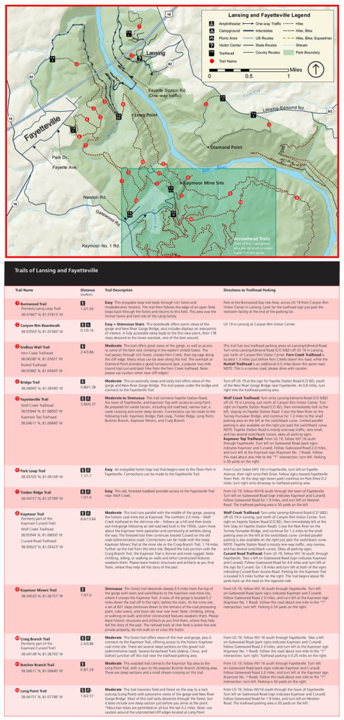
These trails are found in the northern section of the park, just outside the town of Fayetteville. This area of the park is the most popular, and is home to the New River Gorge Bridge. Many trails in this part of the park feature views of the gorge, and of the bridge.
Fayetteville Trails – Easy
| TRAIL | LOCATION | LENGTH | NOTES |
|---|---|---|---|
| Canyon Rim Boardwalk | Canyon Rim Visitor Center | 0.5 mile | Views of New River Gorge and Bridge from top. Steep strenuous stairway leads down to viewing platform. |
| Park Loop Trail | Fayetteville Town Park | 1.1 miles | Short loop trail that connects to Fayetteville Trail. |
| Burnwood Trail | Burnwood Day Use Area – Near Canyon Rim Visitor Center | 1.2 miles | Loop trail through forest to open field. Historical home site. |
| Timber Ridge Trail | Newton Road – See link | 1 mile | Heavily forested trail connects with Fayetteville Trail. |
Fayetteville Trails – Moderate
| TRAIL | LOCATION | LENGTH | NOTES |
|---|---|---|---|
| Butcher Branch Trail | Kaymoor No. 1 Road – See link | 1.2 mile | Steep trail connects Kaymoor Top to Long Point Trail. Access to Butcher Branch climbing area. |
| Craig Branch Trail | Kaymoor No. 1 Road – See link | 2.5 mile | Forested Trail with water features, steep cliffs and views. Old gravel road with several steep sections. |
| Long Point Trail | Newton Rd. – See link | 3.2 mile | Easy trail through field and forest – last .2 miles include steep, rooted descent to gorgeous viewpoint. Mountain Bike friendly trail. |
| Endless Wall Trail | Fern Creek Trailhead, or Nuttall Trailhead on Lansing-Edmond Rd. | 2.7 mile | Fabulous trail through wooded landscape with stunning views into gorge. 2.4 mile one-way, but .3 miles on paved roadway makes trail a loop. |
| Kaymoor Trail | Fayette Station Rd or Cunard | 17.6 mile out & back | Trail connects Cunard, on river, with Fayetteville via old mining road. Can be connected to other trails for varying distances. |
Fayetteville Trails – Strenuous
| TRAIL | LOCATION | LENGTH | NOTES |
|---|---|---|---|
| Bridge Trail | Fayette Station Road – South of Bridge | 1.6 mile | Steep, rocky trail with views of New River Gorge Bridge. |
| Kaymoor Miner’s Trail | Kaymoor No. 1 Road | 2 mile | Steep trail with stairs & switchbacks to old mining site. |
| Fayetteville Trail | Wolf Creek Trailhead / Kaymoor Top Trailhead | 8 mile varies | Trail connects numerous other trails in the Fayetteville – Kaymoor area |
Fayetteville Area Trail Map
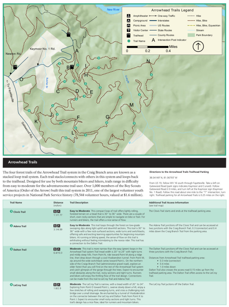
Fayetteville – Arrowhead Detail Map
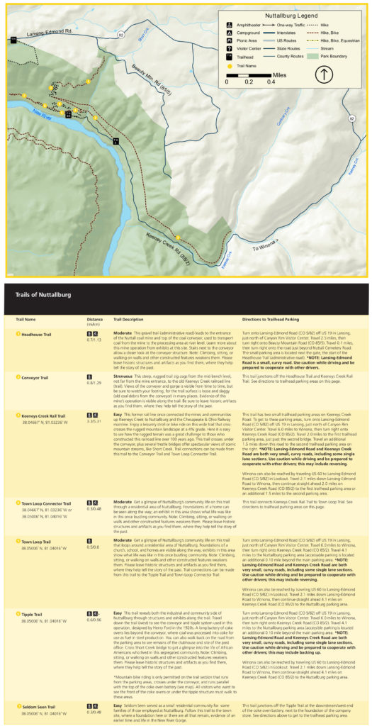
Nuttallburg Trails
Trails in the Nuttallburg area feature the old mining sites that lie strewn through the wooded landscape of the inner New River Gorge. Please note that these historic structures are old and many are quite fragile. Do not climb or walk on the walls or frames of these hazardous structures.
All distances are roundtrip unless otherwise noted.
| TRAIL | Difficulty | LOCATION | LENGTH | NOTES |
|---|---|---|---|---|
| Headhouse Trail | Moderate | Nuttall Cemetery Road | 0.8 mile one way | Old gravel road leads to top of coal conveyor and entrance of mine. |
| Conveyor Trail | Strenuous | Headhouse Trail | 0.6 mile one way | Steep trail runs adjacent to the coal conveyor. Connects Headhouse & Keeneys Creek Trail. |
| Keeneys Creek Rail Trail | Moderate | Keeneys Creek Trailhead | 6.6 mile out & back | This is a gentle 4% graded rail to trail route that once connected mining communities with the C&O Railway. |
| Nuttallburg Loop | Moderate | Keeneys Creek Trailhead | 2.5 mile lollipop | Trail connects Town Loop, Tipple Trail and the Seldom Seen Trails in a tour of the Nuttallburg mine site. |
Nuttallburg Trail Map
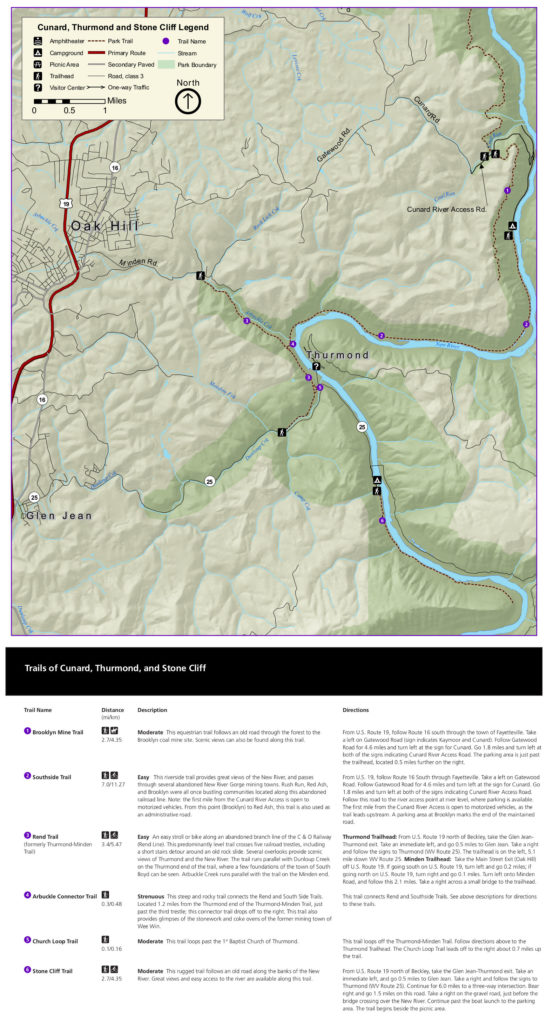
Thurmond Trails
Trails in this area are found deep in the New River Gorge. The first listed hikes on the list below are North of Thurmond, in the Cunard area. These historic trails provide access to a few of the area’s once-bustling, but now abandoned mining towns. All trails in this region are rated easy to moderate and follow old mining roads and railway routes. The Rend, Southside and Stone Cliff Trails allow mountain biking, while the Brooklyn Mine Trail welcomes equestrian travel.
All distances are roundtrip unless otherwise indicated. Trails are easy to moderate, although some will involve slight gradients with moderate elevation gain of a few hundred feet.
| TRAIL | Difficulty | LOCATION | LENGTH | NOTES |
|---|---|---|---|---|
| Brooklyn Mine Trail | Moderate | Cunard River Access Rd. | 6 mile | Trail follows old mining road to abandoned mine site. |
| Southside Trail | Easy | Cunard River Access / Thrumond | 7 mile one way | Flat trail runs along New River, connecting Cunard & Thurmond. Many old mining sites. |
| Rend Trail | Easy | Thurmond or Minden | 2.5 to overlook, or 6.5 mile full hike | Easy trail accesses several scenic overlooks. Runs between the towns of Minden and Thurmond. |
| Arbuckle Connector Trail | Strenuous | Southside or Rend Trail | 0.5 mile | Steep trail connects the Rend Trail to the lower Southside Trail |
| Church Loop Trail | Easy | Thurmond | 2 mile | Short loop cuts off of the Rend Trail to access old Baptist Church |
| Stone Cliff Trail | Easy-Moderate | 1.5 mile south of Thurmond | 6 mile out & back | Moderate, yet somewhat rugged trail leads along river with easy river access |
Thurmond Trail Map
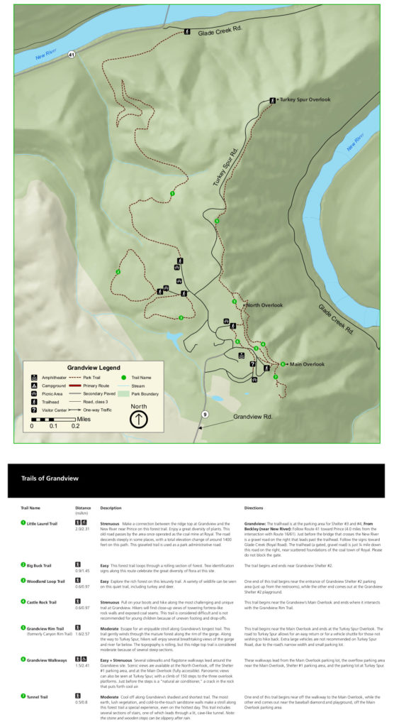
Grandview Trails
The Grandview area provides some of the best scenic eye candy in the park, as the name may suggest. The There are a variety of choices here that offer easy, moderate and strenuous options for an eager hiker.
| TRAIL | difficulty | LOCATION | LENGTH | NOTES |
|---|---|---|---|---|
| Little Laurel Trail | Strenuous | Grandview / Glade Creek Road | 2.7 mile one way | Trail follows old road from Grandview to the New River, 1,400 feet below. |
| Big Buck Trail | Easy | Grandview | 1 mile | Stroll through a classic West Virginia forest with placards that identify hardwood trees. |
| Woodland Loop Trail | Easy | Grandview | 0.6 mile | Leisurely loop winds through wooded forest. |
| Castle Rock Trail | Strenuous – due to exposure | Grandview | 0.5 mile one way | Exciting, but short trail runs along face of cliffs with views of New River Gorge. |
| Grandview Rim Trail | Moderate | Main Overlook / Turkey Spur | 3.2 mile out & back | Trail runs parallel to Turkey Spur Road from Main Overlook to Turkey Spur. Gorgeous views of New River Gorge. |
| Tunnel Trail | Easy | Main Overlook | 0.5 mile | A shady trail leads to a large overhanging rock with a great view. |
Grandview Trail Map
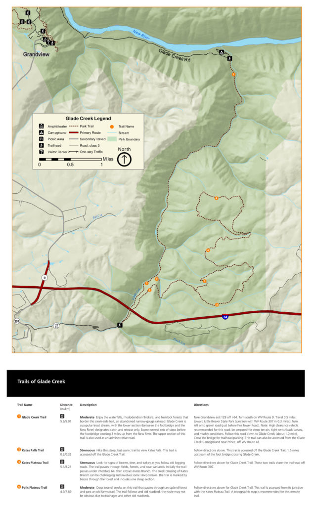
Glade Creek Trails
The Glade Creek trails lie somewhat separated from the New River’s main corridor. The Glades Creek Trail leads to the river along a deep, lushly forested gully which contains numerous swimming holes, while the remaining trails circle a few of the heavily wooded hills that rise to the south of the river.
| TRAIL | Difficulty | LOCATION | LENGTH | NOTES |
|---|---|---|---|---|
| Glade Creek Trail | Moderate | Glade Creek Trailhead – near Prince, WV | 6 mile one way | Trail follows old railway along Glade Creek. Trout stream, good fishing. |
| Kates Falls Spur | Strenuous | Spur off of Glade Creek Trail | 0.25 mile | Spur trail leads up steep slope to waterfall. |
| Kates Plateau Trail | Strenuous – due to washouts | Glade Creek Upper Trailhead | 7 mile lollipop | Old logging road through fields, forests and marshlands leads to plateau that is home to a diversity of wildlife. |
| Polls Plateau Trail | Moderate | Polls Branch Road | 5 mile loop | Tranquil trail through dense forest with access to old homestead. Route may be confusing. |
Glades Creek Trail Map
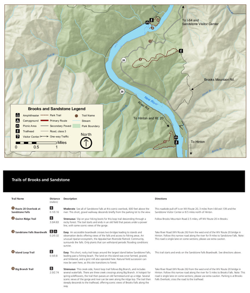
Sandstone Falls Trails
Sandstone Falls is one of the more popular scenic attractions in New River Gorge National Park, and the surrounding area has a few hiking trails that add to the allure of the park’s southern region.
| TRAIL | Difficulty | LOCATION | LENGTH | NOTES |
|---|---|---|---|---|
| Sandstone Falls Loop | Easy | Sandstone Falls | 1.1 mile loop | Scenic loop leads through farmland to views of Sandstone falls. |
| Gwinn Ridge | Moderate + | Brooks Mountain Road | 3.1 mile loop | Quiet forest trail leads around a long ridge. Not many river views, but good color in spring and fall. |
| Big Branch Trail | Strenuous | Brooks Falls Overlook | 2 mile loop | A great springtime hike. Wildflowers line a lightly forested trail that leads past cascading waterfalls en route to fabulous views of the Gorge. |
Sandstone Trail Map
For more general information about hiking in the New River Gorge National Park and Preserve, take a gander at the NPS Hiking page.
Climbing in the New
New River Gorge is home to more than 1,600 established rock-climbing routes that offer one of the most challenging vertical playgrounds in the eastern U.S. Most routes on the solid Nuttall sandstone walls of the upper gorge are not welcoming to beginners, with most routes falling into the 5.10 – 5.12 range. Climbs can run anywhere from 40 to 150 feet in height.
Climbers at The New find a multitude of features on which to test their skill. Arêtes, dihedrals, long splitter cracks, and tiered roofs combine with large technical slabs to provide a full array of problems that will send some folks scampering back to their cozy lil gyms.
read moreThe area is no secret, and the crags can become quite crowded on weekends, so it may be wise to do a bit of research before arrival, and to have a few back up plans in the bag in case your chosen routes are occupied by a group of can kickers.
While the crags are open year round, the most enjoyable time to climb here is spring and fall, although a nice Appalachian rain may find you at any time. The summers can be hot and humid, and the winters are often frigid, so these seasons may be better suited for other activities.
There are a number of climbing guides available for the area, and you’ll probably want to have such a library of information if you’re considering a climbing trip to The New. There are a few options available, but the New River Gorge Climbing Guide Vol 1 by Mike Williams will likely set you up for success. This is the third edition, and is reported to be the most comprehensive guide book for the New River Gorge. You can order the book in the link.
For more online information about climbing in the New, check out the Mountain Project website and make a plan.
For information about route closures and general information about climbing in the New, check out the NPS Climbing page.
Whitewater Rafting
Fifty three miles of free-flowing water churn through the depths of the New River Gorge, making this park one of the premier whitewater river running destinations in the United States.
Visitors can utilize the services of any number of professional guide services to escort them down the river, or those with experience and their own boats are welcome to take to the water themselves. No matter which option one opts to employ, an unforgetable day on the waters of Wild and Wonderful West Virginia is sure to satisfy.
read moreThe headwaters of the ancient New River lie far away, in the high mountains of western North Carolina. As the river descends the mountains, it flows northward, crosses Virginia and enters West Virginia, where it soon meets the Bluestone Dam, which marks its entrance into the New River Gorge. Fifty three miles later, the New River’s course is once again inhibited by a dam, this time the Hawks Nest Dam, at which point the New River Gorge bids the water farewell.
Just past the Gorge, the New River meets the Gauley River. Just upstream of this confluence, the Gauley too holds a whitewater mecca, which boasts rapids even more fierce than the New. At this confluence, the two rivers join forces to become the Kanawha River, which flows northward through the Mountain State and eventually meets the Ohio River at Point Pleasant, West Virginia. In total, the New River runs for more than 350 miles before meeting the Gauley.
There must be something about the New River Gorge that angers the great river. The water enters the park in a peaceful manner, offering the perfect environment for a relaxing float, a few tosses of the ol fishing lure, or even an afternoon nap on the quiet river bank.
A few miles south however, the river becomes a mad beast, hell bent on destroying anything that falls in its path. Raging Class V whitewater rapids toss boaters about as if they were bobbers in a typhoon. Let’s just say there is no opportunity to cast the ol lure here.
Of course, the world is full of people who want to undertake the challenge of scraping by without the penalty of death. We affectionately refer to them as adrenaline junkies. These fine folk flock to the New River to cast their lots. They eagerly jump into rafts and kayaks, and break north with no delay toward the hazardous rocky outcrops which lie barely visible, hidden in the constant spray of water downstream.
If you find yourself in this group, you’ll probably want to give this a shot very soon. I recommend it highly. There are numerous methods by which the common traveler may acquire passage on the river. Here is a link to a guide that may provide a useful bit of technical beta.
Paddling Guide to the New River Gorge
New River Rafting Guides
Most people will opt to join one of the professional rafting companies that offer such activities. There are numerous outfits that provide a variety of adventures on the New, as well as the nearby Gauley. Trips range from the short and sweet, to all day multi-rapid affairs that will leave participants stumbling upon reintroduction to the beloved shoreline.
A number of guide services are available, and a quick internet search will present your choices. Here are a couple to get you started.
Adventures on the Gorge – Whitewater Rafting
Ace Adventures – New River Whitewater Guides
Be sure to check out the park service page on whitewater rafting for more information and current conditions.
Fishing the New
Not everyone who comes to the New River Gorge fishes, but anyone who fishes in West Virginia has a desire to fish in the New River Gorge.
This section of the New River has a wild diversity of fish, and its warm waters are ripe with a healthy population of bass, bluegill, carp, channel cats, crappie, muskellunge and walleye. Several of the park’s tributary streams team with trout as well. If you have a fishing rod along on your travels, a few hours on the banks of the New may just make your day.
read moreThe park has numerous public river access points, most of which can be reached by auto. The Glade Creek Campground provides a wheel chair accessible fishing area. Spring and fall provide an angler with the best fishing conditions, as the water temperatures at these times of year facilitate an increase in fish activity, as well as feeding.
Early mornings and late evenings seem to produce the best results, although a few fish also feed at night, which means you can sit out there all night. Who knows, the lucky night angler may even bag the elusive snipe… (not a fish)
Anglers in New River Gorge must have a valid West Virginia fishing license and should be proficient in catch & release tactics. Likewise, a knowledge of species and the current regulations concerning each species will assure that the populations of each species are adequately maintained, and will ensure that the future is bright for fishing in the New.
New River Gorge Fishing Guides
For those who want a guide to take them right to the hotspots, a number of commercial fishing guides are available who may increase your likelihood of success. A quick internet search will list a few such services for you. Here are a couple to get you started.
Ace Adventures – Fishing Guides
Pro River Outfitters – Fishing Guides
Fishing License & Regulations
Visitors can purchase a fishing license online at the link below.
West Virginia Department of Natural Resources
Also, make sure to be up to date on current fishing regulations.
Current West Virginia Fishing Regulations
Check out the park service fishing page in order to stay current on conditions and regulations regarding fishing in the New River Gorge.
Hunting in the New
It will likely surprise many visitors to find that hunting is permitted in the New River Gorge National Park and Preserve. Indeed, travelers packing for a vacation to most national parks don’t pack their 30-06 in their bags.
Hunting is a way of life in many rural areas. This region of Appalachia holds a long tradition that embraces the taking of game, and the sustenance that comes from this sacred practice provides food for many families. So if you dream of taking a big whitetail buck in the mountains of West Virginia’s newest national park, this is as fine a destination as any.
read moreMuch importance is given to names in the parks, and the “preserve” designation is meant to convey the message that this section of land is a park, but it is a different sort of park. Preserves allow hunting and a limited amount of mineral extractions, depending upon the individual preserve.
In the case of the New, this indicates that hunting is allowed on some 65,000 acres of forested land. The roughly 7,000 acres of the national park section is generally held within the gorge itself, and very little hunting is allowed in this area, but visitors should nevertheless be aware of the practice.
Sixty-five-thousand acres of the New River Gorge National Preserve enable the pursuit of wild game during legal seasons. Hunters must be keenly aware of their location in the preserve, as well as the local regulations, which may differ in the National Preserve from what many are accustomed to “back home”.
West Virginia Hunting License
Hunters must have a current West Virginia hunting license and have proof of passing a hunter’s safety course. See the Department of Natural Resources link below to acquire these needed documents.
West Virginia Department of Natural Resources – Hunting License
West Virginia Department of Natural Resources – Hunter Safety Course
West Virginia Hunting Regulations
Hunters in the New River Gorge will need to be aware of the current hunting seasons and regulations in the state of West Virginia.
Current West Virginia Hunting Regulations
Be sure to check out the regulations specific to the New River Gorge National Park and Preserve as well.
Mountain Biking
Not many parks have opened trails for mountain bikes yet. For some reason, many parks seem to fear the off-road cyclists, but New River Gorge National Park offers plenty of options for bikers who want to shred some dirt on pedal bikes, as E-bikes are restricted to roadways in the New.
The park’s trails are mostly classified in the easy to moderate level, and I’m not sure if any would really be considered difficult by avid mountain bikers. That said, Park Junkie has not yet ridden here, so I really can’t provide any accurate details about trail ratings. But stay tuned, and you’ll be the first to know when I can.
read moreThe trails here are not exclusive to bikers, so there will also be pedestrians to consider, and a few trails present the chance that riders will encounter those engaging in equestrian pursuits. In each of these cases, the biker must cede the right-of-way.
Arrowhead Trails
The most popular trails for biking in the park are found in the Arrowhead area, which contains a cluster of trails that are arranged in a stacked loop system, just outside of Fayetteville. These four trails are rated moderate to difficult, so if ya wanna get on it, this is your spot.
Btw: The construction of these trails calls for a shout out to the Boy Scouts in the Order of the Arrow, who donated 78,544 volunteer hours to build the trails. Nice work boys…
| TRAIL | Difficulty | LOCATION | LENGTH | NOTES |
|---|---|---|---|---|
| Adena Trail | Moderate | Arrowhead | 3 miles | Fast descents with long climbs. |
| Clovis Loop | Easy | Arrowhead | 1 mile | Shortest and easiest trail in the area. |
| Dalton Trail | Moderate | Arrowhead | 7 miles | Longest trail in area. Some rocky terrain. |
| LeCroy Trail | Moderate | Arrowhead | 2 miles | Smooth and flowy. |
Fayetteville Trails
Some of these trails connect to the Arrowhead Trails. Most of the hiking trails in the area permit mountain biking, and some descent riding can be obtained. Keep a check on your downhill speed, as a few of these have abrupt turns with steep drops into the unknown.
| TRAIL | Difficulty | LOCATION | LENGTH | NOTES |
|---|---|---|---|---|
| New River Coal Country | Difficult – length | Fayetteville to Brooklyn Mine | 32 miles | Long ride combines old roads with smooth singletrack. 70% singletrack. See link. |
| Park Loop Trail | Easy | Fayetteville town park | 1 mile | Loops around town park. Connects to Fayetteville Trail. |
| Fayetteville Trail | Moderate | Fayetteville area | 4 miles/ 1way | Trail connects Fayetteville to Kaymoor Trail. |
| Timber Ridge | Moderate | Fayetteville to Long Point | 1 mile/ 1way | Singletrack on old forest road. |
| Long Point | Moderate | Long Point Trailhead | 1.6 mile/ 1way | Smooth ride to Long Point. Bikes not permitted last .2 miles to point. |
| Kaymoor Trail | Moderate | Fayetteville to Brooklyn | 9 mile/ 1way | Doubletrack connects Fayetteville Trail to Brooklyn Mine Trail. Parallels New River. |
| Craig Branch Trail | Moderate | Arrowhead area | 2.4 mile/ 1way | Connects Arrowhead Trails with Kaymoor Trail. |
| Brooklyn Mine Trail | Moderate | South end of Kaymoor | 2.9 miles | Trail runs to Brooklyn Mine from Kaymoor |
Nuttallburg Trails
A few mountain bike friendly trails exist on the eastern side of the New River, although not many. Most of those that allow biking are found in the Nuttallburg Mine area. It should be noted however, that these trails are not biking trails, and the bike is simply a method of travel here… It may not be that enjoyable.
| TRAIL | Difficulty | LOCATION | LENGTH | NOTES |
|---|---|---|---|---|
| Keeneys Creek Rail Trail | Moderate | East of Lansing-Edmond Rd. | 7 mile RT | Old rail to trail singletrack runs to the Nuttallburg Mine site. |
| Town Loop Connector | Difficult | Nuttallburg | 0.5 mile RT | Connects Keeneys with Tipple Trail. |
| Tipple Trail | Easy | Nuttallburg | 1 mile RT | Trail provides access to old mining site. |
| Seldom Seen Trail | Easy | Nuttallburg | 0.6 RT | Trail runs through old mining site. |
| Headhouse Trail | Difficult | Nuttallburg | 1.5 miles RT | Not much info exists on this for mtb riding. It may suck. |
Thurmond Trails
There are a few mellow trails in the Thurmond area that can provide a relaxing ride. A couple these are quite popular.
| TRAIL | difficulty | LOCATION | LENGTH | NOTES |
|---|---|---|---|---|
| Rend Trail | Easy | Thurmond / Minden | 6.5 RT | Runs on old C&O railway line. |
| Southside Junction | East | Thurmond | 14 miles RT | Out & back ride along the New River on old railway. |
| Stone Cliff Trail | Easy | Thurmond area | 6 miles RT | Old rugged roadway provides ride along river. |
Grandview Trails
There area some excellent views from this area, but only one biking trail. This one may be a bit rugged and doesn’t seem to see much bike traffic. But it is there is ya wanna get some.
| TRAIL | difficulty | LOCATION | LENGTH | NOTES |
|---|---|---|---|---|
| Little Laurel Trail | Difficult | Grandview | 5.5 miles RT | Runs from Grandview to New River. 1,000 feet elevation. |
For more information on mountain biking in the New River Gorge, check out the park’s mountain biking page.
Scenic Drives
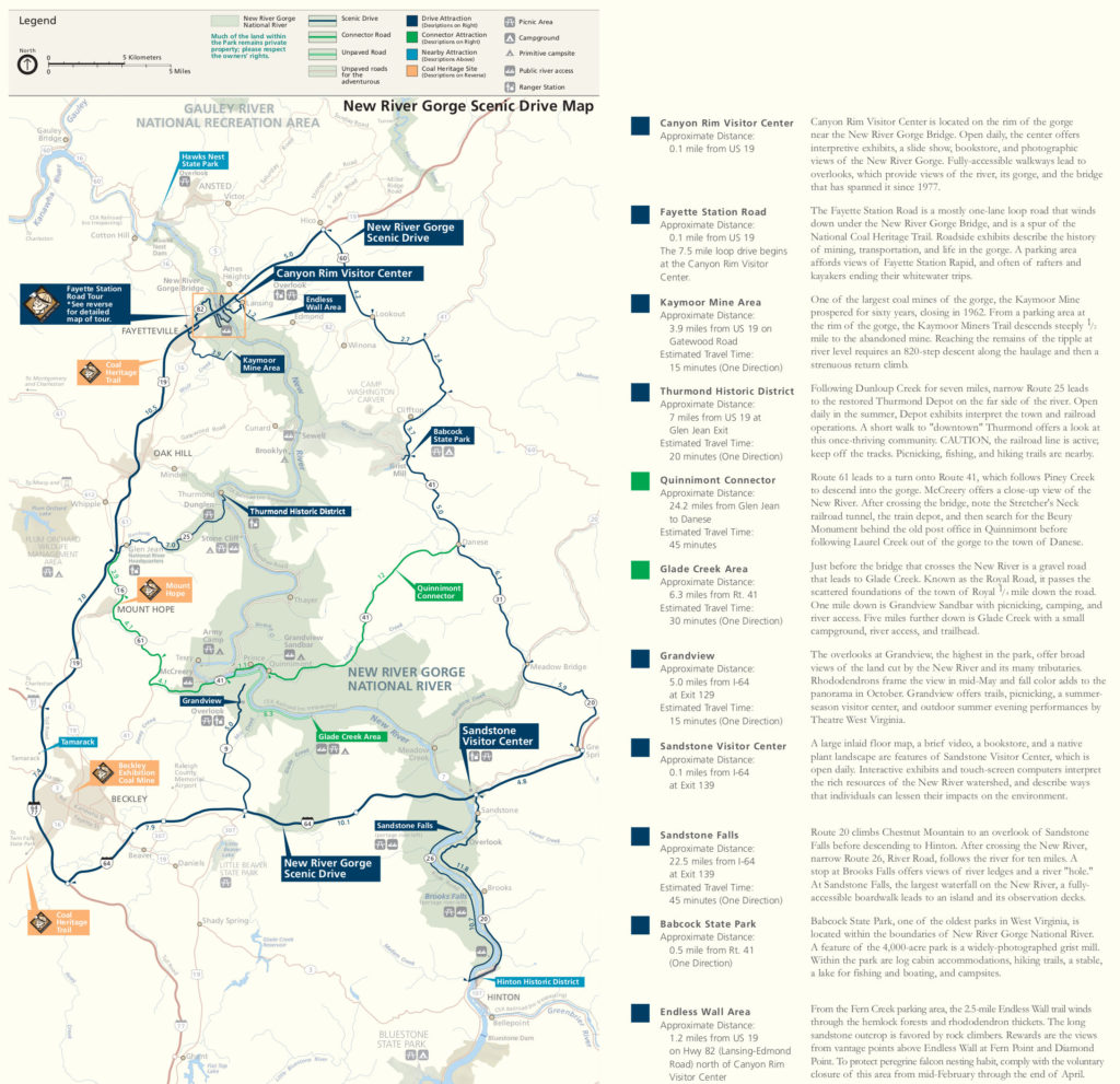
There are a number of scenic drives in the park which provide access to an array of stunning vistas. Due to the complex geography of the New River Gorge, these drives will wander in and out of the park boundaries.
Drivers can enjoy a nice drive in the New any time of year, but the most enjoyable scenery may appear in the fall months, when the kaleidoscope of colors in the gorge presents magical views that simply don’t exist during the other months.
read moreThe most popular route involves a 3-hour circumnavigation of the gorge. Much of the drive is removed from the actual park, and focuses on the surrounding area, although its path travels along the most scenic areas in the New River Gorge that offer vehicular access.
There are a few options for travelers that offer a bit more park miles. Consider taking Route 41, known as the Quinnimont Connector to eliminate the section of this drive that involves travel on Interstate 64. Park Junkie has little patience for interstate travel on a “scenic drive”.
For those of like mindset, the four-lane highway can be avoided with a few extra minutes on West Virginia’s beautiful backroads that access points such as Grandview and Sanstone Falls. Take a close look at the NPS provided scenic drive brochure below. You’ll see that you can wind through the countryside on a number of paths. Hell, choose your own route and just see what you find. You’ll be stoked.
New River Scenic Drive
The McKendree Road
No roads offer a suitable north south route through the park, although a rugged 4×4 route may provide excellent material for a classic West Virginia white-knuckled-drive.
The McKendree Road, an old unmaintained county road winds along the river and up into the hills, provides the only route of any significant distance in the park that parallels the river. This route once connected the mining and logging town of Thurmond with the supply-line town of Prince, some 7 or 8 miles to the south as the crow flies.
This route is remote and completely unmaintained. Four wheel drive, and offroad driving skill is required. Travel at your own risk, and be prepared to hike a long way out if you get stuck. No one is coming to help you.
For more information about taking the scenic drives around the New River Gorge, check out the park service link below.
Ranger-Led Activities
The national parks hold a full array of activities and opportunities to become intimate with the most incredibly decorated lands our country has to offer. Often our memories in these lands are highlighted by solitary moments in backcountry enclaves of unparalleled beauty.
Other times, such experiences can be enhanced by participation in a park sponsored program that many of us may recall from our earliest years in the parks. Much of a visitor’s knowledge of history, geology or wildlife diversity is often gained by attendance of a ranger-led program. A variety of walks, paddles, rides, and campfire talks are offered in an attempt to provide a better understanding of the national park environment that we find so captivating.
read moreNew River Gorge offers a number of these ranger-led activities which can provide a perfect introduction to some of the park’s highlights. Numerous options exist, each of which is designed to accommodate a variety of abilities and outdoor experience.
These programs are free, unless otherwise indicated and usually provide all equipment necessary to participate in the featured activity. Check out the park website for more information about the Get Active in the Park events.
Guide to New River Gorge
Relevant Links
National Park Guides

All content found on Park Junkie is meant solely for entertainment purposes and is the copyrighted property of Park Junkie Productions. Unauthorized reproduction is prohibited without the express written consent of Park Junkie Productions.
YOU CAN DIE. Activities pursued within National Park boundaries hold inherent dangers. You are solely responsible for your safety in the outdoors. Park Junkie accepts no responsibility for actions that result in inconveniences, injury or death.
This site is not affiliated with the National Park Service, or any particular park.
